

Designed for ArcGIS Online, the app allows Esri users to task a BlackSky satellite and have dynamic, on-demand imagery delivered directly into their ArcGIS Online organization. BlackSky Technology Inc. and […]
Imagery
Capella Space satellite imagery now available on the Amazon Web Services cloud

Capella Space has expanded their Open Data Program, making a selection of the firm’s SAR (synthetic aperture radar) imagery freely and openly accessible through the Amazon Web Services (AWS) Open […]
Lockheed Martin-developed NIRCam within NASA’s James Webb Space Telescope captures a galaxy cluster as it appeared billions of years ago

NASA has released the first image of some of the earliest light in our universe, taken with an instrument that Lockheed Martin (NYSE: LMT) designed and built. The debut photo […]
Planet’s SkySat views of a now abandoned Snake Island, Ukraine

Planet has released their latest satellite imagery of Snake Island, Ukraine. This SkySat imagery of the island, which is a strategic, Black Sea outpost that Russian forces have allegedly abandoned, […]
Synspective + Addvalue form partnership + plan to strengthen EO services with fast customer response
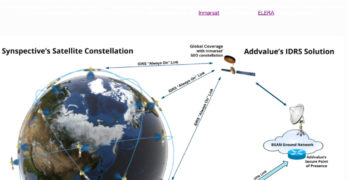
Synspective Inc. and Addvalue Innovation are partnering to enable urgent delivery of high-quality imagery in challenging disaster environments. The collaboration will leverage Addvalue’s Inter-satellite Data Relay System (IDRS™) implemented over […]
Ursa Space’s Image Archive Ordering And New Tasking Now Available For Purchase On Amazon Web Services Data Exchange

Each week, Ursa Space ingests approximately 25,000 SAR images into its image services database, equivalent to 1.5 petabytes of total archival imagery. Customers can now purchase Ursa Space’s Synthetic Aperture […]
Amazon Web Services Names The 10 Participants For Their 2022 AWS Space Accelerator Program

Amazon Web Services (AWS) has selected 10 participants for the 2022 AWS Space Accelerator — this year’s finalists brought forward pioneering ideas that will draw valuable insights from the depths […]
AAC Clyde Space’s Follow-On Order For Europe’s New Weather Satellites, MetOp-SG

The MWIs will provide cloud and precipitation products and all-weather surface imagery to support numerical weather predictions at regional and global scales. Omnisys, AAC Clyde Space’s new subsidiary, secured an […]
NOAA Is Predicting A Below-Normal 2022 Central Pacific Hurricane Season

There is a 60% chance of below-normal tropical cyclone activity during the Central Pacific hurricane season this year, according to NOAA’s Central Pacific Hurricane Center and NOAA’s Climate Prediction Center, […]
SI Imaging Services + GHGSat Operating Together @ The World Gas Congress In South Korea

SI Imaging Services (SIIS) will operate a joint booth with GHGSat at the World Gas Congress 2022 (WGC) held at EXCO in Daegu, South Korea, from the 23rd of May […]