

Edgybees has released their Satellite Software to enhance the accuracy of satellite imagery. Edgybees Satellite Software aligns electro-optical satellite imagery to ground truth, within two to three meters of accuracy, […]
Imagery
Orbital Insight + Satellogic Share Their Expertise — Bringing Sat Imagery + FMV To Platform + More

Orbital Insight has partnered with Satellogic (NASDAQ: SATL) and the company’s will integrate the latter’s high-frequency, high-resolution collections of satellite imagery and full-motion video (FMV) into the Orbital Insight platform […]
Maxar Makes Strategic Investment In blackshark.ai To Extend Geospatial Capabilities

Maxar Technologies (NYSE:MAXR) (TSX:MAXR) has engaged in a strategic investment in Blackshark.ai, a provider of AI-powered, geospatial analytics services — this partnership represents Maxar’s commitment to innovation within the firm’s […]
ScanWorld and SPACEBEL’s Merge With ConstellR Will Optimize Sustainable Farming Worldwide

Thermal infrared imagery enables measurement of water-related features such as the evapotranspiration of plants, impact of drought providing smart crop monitoring. ScanWorld (Belgium), a SPACEBEL hyperspectral imagery initiative specializing in Earth […]
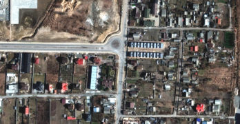
Maxar’s Satellite Imagery Captures Russian Redeployments + Offensive Movement Into Eastern Ukraine And Supply Depots

Recent Maxar satellite imagery reveals that Russian ground forces continue to redeploy and move into eastern Ukraine, likely in preparation for a renewed offensive and military operations in the Donbas […]
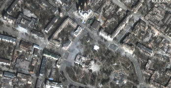
Maxar’s Satellite Imagery Captures Of Bucha, Ukraine, + Verification Of Mass Graves
The battle continues, with Russia concentrating their forces to the east and south of Ukraine. High-resolution Maxar satellite imagery collected over Bucha, Ukraine (northwest of Kyiv), verifies and corroborates recent […]
Four Dedicated Antennas Finalized + Commissioned By KSAT For Satellogic

KSAT has finalized and commissioned dedicated antennas for Satellogic. Four dedicated antennas for the disruptive satellite company are up and running at Troll Station and Svalbard, showing KSATs ability to […]
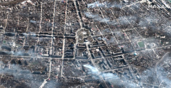
As The Russian Barrage Of The Ukraine Continues, Maxar’s Satellite Imaging Of The War Continues
Maxar collected new high-resolution satellite imagery of Mariupol, Ukraine, on March 29th that shows extensive damage to residential apartment buildings, homes and civilian infrastructure caused by weeks of Russian artillery […]
Maxar’s Satellite Imagery Captures Mariupol Area Russian Attack Damage + Flooding North Of Kyiv

As of March 22nd, Maxar has collected new high-resolution satellite images of Mariupol that vividly shows the widespread destruction caused by Russian artillery shelling and airstrikes on residential housing areas, […]
Maxar Continues To Capture Satellite Imagery Of The Russian-Ukraine Invasion
New Maxar satellite imagery collected March 18 to March 21, 2022, reveals continued Russian military activity in and around a number of key Ukrainian cities that include Mariupol, Kyiv and […]