

Maxar’s recent satellite imagery reveals significant damage to residential and civilian infrastructure in and around multiple Ukrainian cities, including Volnovakha, Chernihiv and Kharkiv. Russian self-propelled artillery and multiple rocket launchers […]
Imagery
Capella Space Adds Their Satellite Imaging Of The Russian-Ukrainian War
All imagery in this posting is ©2022 Capella Space.
Mariupol, Bridge Down, Moschun, Before + After Of Snake Island Attack… Russian Invasion Imagery Captures Continued By Maxar

New Maxar satellite imagery collected on March 14th reveals additional damage throughout the southern Ukrainian city of Mariupol. Fires continue to burn across the city and many high-rise apartment buildings […]
Russian Attack Damage To Hospital, Civilian Infrastructure + Industrial Areas Revealed In New Maxar Satellite Imagery
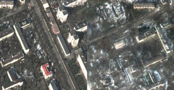
Maxar collected new satellite imagery on Saturday, March 12th, of Mariupol, Ukraine, that reveals extensive damage to civilian infrastructure and residential buildings throughout the city. Fires are seen in the […]
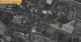
UPDATE: Russian Assault On Ukraine Satellite Imagery Captures — Artillery + Homes / Airport Destruction / Airport Battered / Residential Damages / Chernobyl

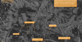
Maxar’s satellites collected an extensive amount of imagery (more than 15,000 square kilometers collected on March 11) over Kyiv, Chernihiv and Pripyat/Chernobyl that provides new visual details of the ongoing […]
Maxar Imagery Continues To Reveal The Extent Of The Russian Attack On Ukraine

Maxar collected new satellite imagery on March 9, 2022, of the besieged southern Ukrainian city of Mariupol. The imagery was collected at 10:16 a.m., local time. Extensive damage is noted […]
Critical EO Data Will Be Distributed To The Ukrainian Government By Satellogic + Astraea
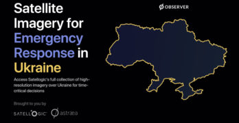
Satellogic Inc. (NASDAQ:SATL), in collaboration with Astraea, will distribute critical Earth Observation (EO) data directly to the Ukrainian government, allied governments and humanitarian organizations on the ground. Satellogic is providing […]
Maxar Releases Video Clips Of Russian Convoy Outside Kyiv, Ukraine

On Monday, February 28th, Maxar distributed high-resolution satellite images of the Russian military convoy that covered approximately 40 miles in an area northwest of Kyiv, Ukraine. That imagery was produced […]
Maxar Technologies’ Continued Satellite Image Captures of the Russian-Ukrainian War

From March 1 to March 2, heavy cloud cover has blanketed Ukraine and prevented Maxar from providing new satellite imagery-based imaging opportunities of the current war. The company continues to […]
Capella Space Publishes SAR Imagery Of The Ukraine-Russia Crisis
Capella Space has captured SAR imagery are from the airfield at Rodnykivka (48.7932 LAT, 30.2086 LONG – captured 2/26 at 10:05 am UTC) in the Ukraine. All imagery is copyright […]