

Landsat 9, a joint mission from NASA and the U.S. Geological Survey, was launched on September 27, 2021, and has now collected its first images of Earth. These images, all […]
Imagery
Terran Orbital Enters A SPAC Business Combo Agreement With Tailwind Two Acquisition Corp.

Tailwind Two Acquisition Corp. (NYSE:TWNT) (“Tailwind Two”), a special purpose acquisition company (SPAC), and Terran Orbital Corporation, a developer, innovator and operator of smallsats and Earth Observations (EO) solutions, have […]
DoD’s DIU Strengthens Domestic, sUAS Base With 8 Awards

As part of the nation’s effort to ensure a robust small unmanned aerial systems (sUAS) industrial base for national and economic security, the Department of Defense’s (DoD) Defense Innovation Unit […]
The First Commercial Order For Creotech’s HyperSat Smallsat Platform Is Received

Creotech Instruments S.A., in cooperation with the Military University of Technology in Poland, recently initiated the process of building a constellation of three satellites. The cooperation takes place as part […]
NGA Awards Maxar With G-EGD Contract Renewal For Mission-Ready Satellite Imagery

Maxar Technologies (NYSE:MAXR) (TSX:MAXR) has been awarded an Option Year 2 contract renewal by the U.S. National Geospatial-Intelligence Agency (NGA) for the Global Enhanced GEOINT Delivery (G-EGD) program. The contract, […]
Euroconsult Projects A $7.5 Billion Earth Observation Data & Service Market By 2030

The Earth Observation (EO) market has undergone shifts in financing, with optical constellation operators going public to accelerate their deployment and to develop new services. Furthermore, the EO market experienced […]
Orbital Logic’s SpyMeSat Now Available On The Web
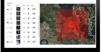
Orbit Logic‘s SpyMeSat is now available through a web-based browser interface. SpyMeSat Web1 provides the same capabilities as the mobile app. Users can seamlessly transition between mobile and web platforms […]
NASA Selects SpaceX To Launch GOES-U

NASA has selected Space Exploration Technologies (SpaceX) of Hawthorne, California, to provide launch services for the Geostationary Operational Environmental Satellite-U (GOES-U) mission. GOES-U will provide advanced imagery and atmospheric measurements […]
September 11, 2001 — Let Us Never Forget! Maxar’s Satellite Imagery Of The Attacked Target Sites, Collected Directly After The Airborne Aggression

America is approaching a somber milestone: the 20th anniversary of the September 11, 2001, terrorist attacks. That morning, four commercial airplanes were hijacked: two crashed into the World Trade Center […]
Satellite Imagery Of The Destructive Caldor Fire Near South Lake Tahoe Captured By Maxar

Thanks to the imagery collection resources of Maxar, views of the destructive Caldor wildfire as the conflagration approaches the southern edge of Lake Tahoe along the California-Nevada border reveal the […]