• Skip to primary navigation
  • Skip to main content
  • Skip to primary sidebar
  • Skip to secondary sidebar
  • NEWS:
  • SatNews
  • SatMagazine
  • MilSatMagazine
  • SmallSat News
  • |     EVENTS:
  • SmallSat Symposium
  • Satellite Innovation
  • MilSat Symposium

SatNews

  • HOME
  • Magazines
  • Events
  • SmallSat Europe Insights
  • Industry Calendar
    • IN PERSON
    • VIRTUAL
  • Subscribe

Synspective develops a “Slope Instability Detection Feature” for predictive changes + pre-disaster ground deformation with SAR data analysis

August 25, 2022

Synspective develops and operates Synthetic Aperture Radar (SAR) satellites and provides solutions based on satellite data analysis.

The company developed a ground deformation analysis device and method with a slope instability detection feature that identifies predictive changes of landslides and other disasters. The firm also filed a patent application (PCT/JP2022/026506) for their new invention.

Synspective has been offering their Land Displacement (LDM) solution service that employs SAR satellite data features to analyze wide-area ground deformation and provide actionable insights and results. This service can monitor ground changes in millimeter accuracy and display them in time-series order. In April of 2021, the firm released a subsidence extraction feature that identifies potential land deformation and sinkhole occurrence (pending patent application: PCT/JP2021/003312) with the LDM service.

Natural disasters, such as heavy rains, floods, and earthquakes, have a significant impact on the environment and threaten people’s safety all over the world. Synspective believes it is important to monitor ground changes as well as to detect early disaster warning signs and issue alerts accordingly. With a new feature that can predict potential areas of ground subsidence, the company has developed an analysis device and method to detect precursors of ground disasters such as landslides and slope failures.

Select this direct link to read “ Use cases of InSAR analysis for landslide disasters.”

Analysis Result Images: 1 — Distribution of unstable fluctuation points in local areas (Source:Esri,Earthstar Geographics, ©Copernicus Sentinel data [2021], ©Synspective In)
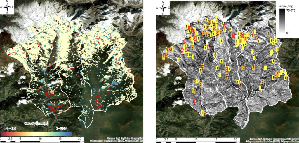
2 — Risk level display based on distribution of hotspot areas where ground deformation and changes are evident (Source:Esri,Earthstar Geographics METI/NASA, ©Copernicus Sentinel data [2021], ©Synspective Inc)

With this technology, ground deformation situations can be understood, including when and where a change that could be a precursor to a disaster is occurring as well as to detect early disaster risk warning signs. For example, it is possible to detect precursory phenomena before a ground disaster occurs.

Additionally, the company can grasp a ground deformation situation and issue a warning by detecting precursory points in the saliency-based index within the time-series data.

Synspective develops and operates satellites and also develops new solution services and analysis technologies. In recent years, natural disasters have been occurring more frequently and have left enormous damage and destruction in their wake. Synspective hopes that new technologies with satellite data will make substantial progress toward realizing a safe and sustainable society.

Filed Under: Constellation, Data Analytics, Emergencies, Ground Deformation, SAR, Satellites, SmallSat, Synspective Tagged With: Featured

Primary Sidebar

Most Read Stories

  • Space Debris, and the EU’s Space Act
  • In celebration of Juneteenth
  • Wishing Everyone a Happy July 4th … Independence Day, U.S.A.
  • Eutelsat's efforts to obtain funding to save OneWeb
  • Forrester's Digest: Starlink active in Iran

About Satnews

  • Contacts
  • History

Archives

  • July 2025
  • June 2025
  • May 2025
  • April 2025
  • March 2025
  • February 2025
  • January 2025
  • December 2024
  • November 2024
  • October 2024
  • September 2024
  • August 2024
  • July 2024
  • June 2024
  • May 2024
  • April 2024
  • March 2024
  • February 2024
  • January 2024
  • December 2023
  • November 2023
  • October 2023
  • September 2023
  • August 2023
  • July 2023
  • June 2023
  • May 2023
  • April 2023
  • March 2023
  • February 2023
  • January 2023
  • December 2022
  • November 2022
  • October 2022
  • September 2022
  • August 2022
  • July 2022
  • June 2022
  • May 2022
  • April 2022
  • March 2022
  • February 2022
  • January 2022
  • December 2021
  • November 2021
  • October 2021
  • September 2021
  • August 2021
  • July 2021
  • June 2021
  • May 2021
  • April 2021
  • March 2021
  • February 2021
  • January 2021
  • December 2020
  • November 2020
  • October 2020
  • September 2020
  • August 2020
  • July 2020
  • June 2020
  • May 2020
  • April 2020

Secondary Sidebar

We use cookies to ensure that we give you the best experience on our website. If you continue to use this site we will assume that you are happy with it.OkPrivacy policy
x
Sign up Now (For Free)
Access daily or weekly satellite news updates covering all aspects of the commercial and military satellite industry.
Invalid email address
Notify Me Regarding ( At least one ):
We value your privacy and will not sell or share your email or other information with any other company. You may also unsubscribe at anytime.

Click Here to see our full privacy policy.
Thanks for subscribing!