
The development of a disaster prevention management system makes progress …
Japan International Cooperation Agency (JICA) and Synspective started a satellite use service demonstration to monitor ground movements in Guatemala City, Guatemala, as part of an information gathering and pilot project.
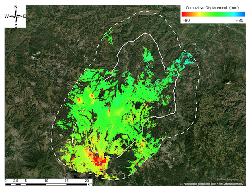
Using “Land Displacement Monitoring” (LDM), a ground deformation monitoring service using satellite data provided by Synspective, conducted a ground deformation analysis for approximately three years (July 2018 to June 2021) in Guatemala City and its suburbs.
As a general trend in Guatemala City, localized subsidence phenomena and areas that show sinkage and landslide risks have been identified. The figure below shows that the maximum subsidence area fluctuated by about -292mm and the maximum uplift area fluctuated by about +88mm.
Detailed analysis of the points that showed characteristic fluctuation trends revealed that three points (red points 1 to 3) were new sinkage risk points that had not been confirmed by conventional survey methods*2.
JICA and Synspective detect new risks in Guatemala using SAR satellite data
The development of a disaster prevention management system makes progress

*1 Counterpart: persons or institutions in charge of site as it pertains to international collaboration and cooperation
*2 Traditional surveying methods for land hazards — In the past, the amount of ground deformation was not measured using satellites, and the counterpart agency staff went to the site as an after-the-fact response when a landslide or other disaster occurred. In addition, risk assessment was conducted using indirect indicators such as landslide inventory based on existing topographical and rainfall information.
This wide-area analysis using satellite data has shown that it is possible to extract new ground deformation and sinkage risks. In addition, the time from analysis to provision of data has been reduced to about 1/3 of the time of conventional methods (compared to the company) due to automatic analysis. The new discoveries made by satellite data and the speedy provision of analysis results are expected to lead to faster implementation of preventive maintenance measures for disaster prevention and mitigation.
In this demonstration project, the LDM will be used by counterpart organizations to evaluate the simplicity, efficiency, and effectiveness of the system. LDM enables easy acquisition of analysis results from SAR satellites and provides analysis results on an easy-to-understand screen display on the web, without requiring environmental equipment such as specialized software or advanced technical knowledge. In terms of functions, the ability to zoom in on the area of interest and automatically create graphs allows for detailed data confirmation and analysis. After evaluating the effectiveness of the system, the company plans to contribute to disaster prevention projects in Guatemala.