• Skip to primary navigation
  • Skip to main content
  • Skip to primary sidebar
  • Skip to secondary sidebar
  • NEWS:
  • SatNews
  • SatMagazine
  • MilSatMagazine
  • SmallSat News
  • |     EVENTS:
  • SmallSat Symposium
  • Satellite Innovation
  • MilSat Symposium
  • SmallSat Europe

SatNews

  • HOME
  • Magazines
  • Events
  • SV SPACE WEEK UPDATES
  • Industry Calendar
    • IN PERSON
    • VIRTUAL
  • Subscribe

Featured

UPDATE 2: SpaceX’s Falcon 9 successfully launches 49 Starlinks and D-Orbit’s Eclectic Elena

January 31, 2023

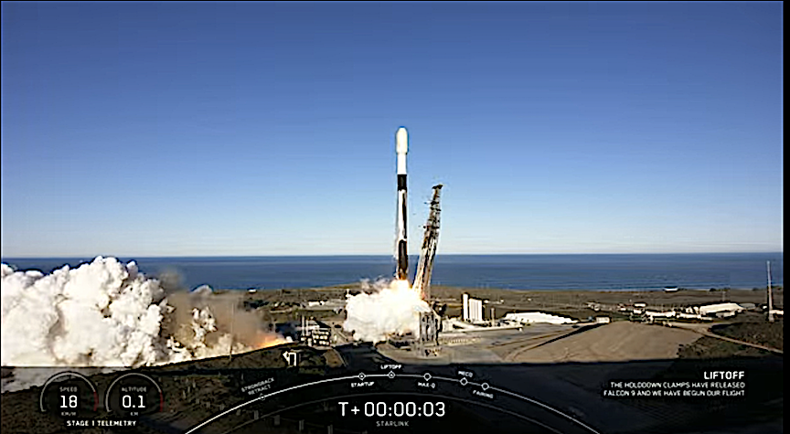
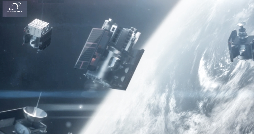
SpaceX‘s Falcon 9 successfully launched 49 Starlink satellites and D-Orbit’s ION SCV009 Eclectic Elena to LEO from Space Launch Complex 4 East (SLC-4E) at Vandenberg Space Force Base in California on Tuesday, January 31st., at 8:15 a.m. , PT, (16:34 UTC).

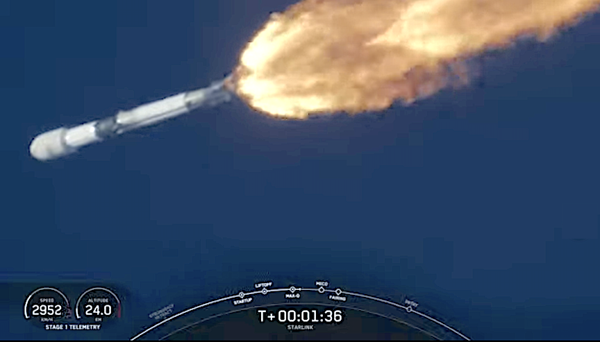
The first stage booster supporting this mission previously launched NROL-87, NROL-85, SARah-1, SWOT, and two Starlink missions.

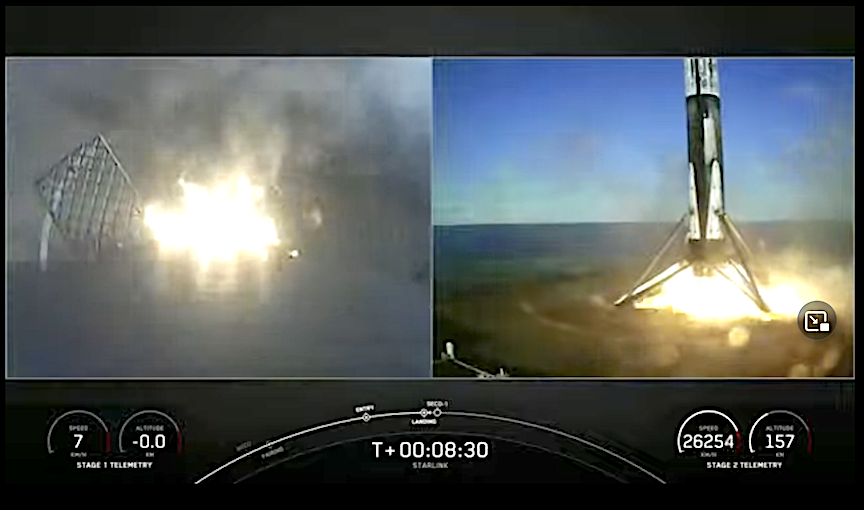
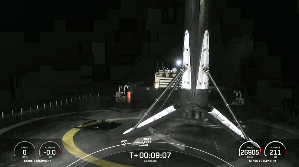
Following stage separation, the first stage landed on the Of Course I Still Love You droneship stationed in the Pacific Ocean.

Filed Under: D-Orbit, Falcon 9, Launch, Launch Management, Launch Systems, Launch Vehicle, SpaceX, Starlink, Vandenberg SFB Tagged With: Featured

SmallSat Symposium 2023: Last week to register… record-breaking attendance for this event!

January 31, 2023

Filed Under: Constellations, Events, Networking, News, Presentations, Silicon Valley, SmallSat, Smallsat Development, SmallSat Symposium 2023, Trade Show Tagged With: Featured

In-Space Missions engaging in an APAC rideshare mission

January 30, 2023

In-Space Missions Ltd. is partnering with Singapore Space Technologies Ltd. (SSTL) to initiate Faraday Dragon, an Asia-Pacific (APAC) regional satellite rideshare mission that is targeted for launch in 2025. Faraday Dragon will fly multiple payloads for regional space players including government, commercial, financial, research and educational organizations.

In-Space Missions, which is owned by BAE Systems, is collaborating with Singapore Space on a service-orientated model which aims to support and develop satellite assembly and payload integration capabilities in Singapore and the Asia-Pacific region. Faraday Dragon will be presented at a workshop facilitated by SSTL at the Global Space and Technology Convention (GSTC) being held in Singapore in February. The workshop will bring together key stakeholders and industry to define a future in-orbit demonstration capability. Core technologies and processes for a variety of applications will be discussed at the workshop including optical payloads (both visible and infra-red), RF sensing, radar, processors, machine learning and artificial intelligence, communications, propulsion, formation flying, metrology and timing.

The Faraday Rideshare satellite platform and service capability has been developed by In-Space Missions, with support from the UK Space Agency, to provide a full turnkey system for enabling diverse organisations to get payloads into space at a very competitive price that cannot be achieved using a dedicated satellite solution. The platform design includes innovative on-board processing to deliver sophisticated, flexible and re-configurable data from multiple sensors on board the spacecraft, providing the potential for a rich flow of data from new technologies for the downstream sector.

Value added services from Faraday Dragon could also include on-orbit processing (edge processing), subsequent timely delivery of actionable information to a user community and a full end-to-end service to customers that includes payload operations support, satellite bus operations, payload tasking and download of data via a Customer Data Portal.

In-Space Missions is also seeking partners and collaborators in theAPAC region for the InSpace Digital system, launching in 2024, to trial payload applications that can be run on the ground or uploaded (or both) and make use of a unique combination of data from multiple optical payloads, Synthetic Aperture Radar and an RF multi-band and wide band collect system.

InSpace Digital is a reprogrammable, multi-sensor system of four satellites that can be repurposed for different applications and commercial use. It can be reprogrammed to use multiple optical payloads and the RF multi-band and wide band collect system on three of the spacecraft, along with the SAR payload on the fourth, to generate pre-processed results to deliver value added data or actionable information to users. The system includes inter-satellite links between the spacecraft, precision timing and metrology and inter-satellite links via GEO for low volume data and tasking.

“The Faraday Dragon rideshare mission is designed to contribute to the regional eco-system by bringing multiple payloads together on one satellite platform to provide a more cost-effective and sustainable ride to orbit for pre-cursor missions, early service rollout, technology demonstration, and in-orbit flight qualification of new technologies. Our customers will be able to access the performance of a 150kg class small satellite for a fraction of the cost of traditional flight services as well as access our in-orbit ‘Digital’ system to take advantage of coherent multi-sensing and processing,” said Tony Holt, Chief Sales Officer for In-Space

“We are excited to be working with In-Space Missions to bring a low-cost option to space players in the Asia Pacific region. One of the biggest challenges faced by emerging players developing frontier space technologies is the cost of space heritage. It is through partnerships like this that SSTL is able to support cutting edge innovation by lowering the barriers to entry,” said Jonathan Hung, Executive Chairman at Singapore Space and Technology Limited.

Filed Under: APAC, BAE Systems, Constellation, In-Space Missions, Launch, Multiple Payloads, Rideshare Mission, Singapore Space Technologies Ltd., SmallSat, UK Space Agency Tagged With: Featured

Space Flight Laboratory (SFL) confirms successful deployment of HawkEye 360 Cluster 6 smallsats

January 30, 2023

Space Flight Laboratory (SFL) has announced that ground control has successfully established communication with three radio frequency (RF) geolocation smallsats developed by SFL for HawkEye 360 of Herndon, Virginia.

Cluster 6 was launched on January 24, 2023, on the inaugural flight for Rocket Lab’s Electron Rocket from Wallops Island, Virginia. This successful mission brings to 18 the number of HawkEye 360 smallsats built by SFL and now on-orbit.

The HawkEye 360 Constellation detects and geolocates RF signals for maritime situational awareness, emergency response, national security, and spectrum analysis applications. To boost revisit rates over the mid-latitude regions of the globe, Cluster 6 was launched into an inclined orbit. Upon commissioning, HawkEye 360 will be able to collect RF data as frequently as every hour anywhere in the world.

Artistic rendition of HawkEye 360’s Cluster 6 smallsats on-orbit, courtesy of the company.

HawkEye 360 selected SFL due to the importance of formation flying by multiple satellites for successful RF geolocation. Clusters 2, 3, 4 and 5 have all been built on SFL’s space-proven 30 kg DEFIANT microsatellite bus. SFL’s formation flying technology enables the Virginia company to offer the most timely and actionable RF data and data analytics available on the market.

“Cluster 6 launched as planned to support expansion of the HawkEye 360 constellation as it scales to meet the growing worldwide demand for its commercial RF data and analytics services,” said SFL Director, Dr. Robert E. Zee. “SFL’s trusted attitude control and formation-flying capabilities deliver the stability and accuracy required for precise RF geolocation.”

SFL offers a complete suite of nano-, micro- and small satellites – including high-performance, low-cost, CubeSats – that satisfy the needs of a broad range of mission types from 3 to 500 kilograms. Dating from 1998, SFL’s heritage includes 64 operational successes with more than 225 cumulative years of operation in orbit and 28 currently under construction or awaiting launch. These missions relate to Earth observation, atmospheric monitoring, ship tracking, communication, radio frequency (RF) geolocation, technology demonstration, space astronomy, solar physics, space plasma, and other scientific research, utilizing core SFL-developed components such as modular (scalable) power systems, onboard radios, flight computers, and control software.

Filed Under: Commissioning, Ground Control, HawkEye 360, News, RF Geolocation Satellites, Space Flight Laboratory (SFL) Tagged With: Featured

The Spanish Ministry of Defence contracts Indra for Spanish airspace surveillance + control centers

January 29, 2023

The Spanish Ministry of Defence has awarded Indra a project to modernize and upgrade the nation’s command, surveillance, identification and control (ARS) centers that are essential for combating potential threats to the country’s airspace.

Indra Lanza 3D radar.

Indra will equip the ARS centers in Torrejón de Ardoz in Madrid (GRUCEMAC), Zaragoza (GRUNOMAC) and Gando in Gran Canaria (GRUALERCON) and the Command and Control School (EMACOT) with the company’s next-generation AirDef air command and control system, which will contribute to the mission for the permanent surveillance and control of airspace national sovereignty led by the Spanish Air and Space Force.

With this project, the Ministry of Defence will rely on Indra’s proprietary development solutions, as it did in the late 1990s with the IARS system that is currently in service at the above named centers. This system, together with the Lanza 3D radars in the Air Surveillance Squadrons (EVAs), forms the backbone of airspace surveillance and control in Spain.

Thanks to the modernization of the ARS centers with the new AirDef system, which incorporates anti-missile defence for the first time, and the new and more advanced Lanza 3D radars that Indra will continue to deploy, Spain’s status as a country with one of the most comprehensive and integrated air and anti-missile defence systems in the world and a global leader in this sphere will be reinforced.

AirDef, which is already operational in several countries around the world, has been designed to meet NATO’s demanding air command and control requirements to facilitate its contribution to the Alliance’s Integrated Air and Missile Defence System (NATINAMDS), ensuring its essential and ongoing mission during times of peace, crises and conflicts to safeguard and protect the Alliance’s territory, populations and forces against any air or ballistic missile threat or attack.

Patriot air and missile defence system on display at Allied Air Command (© NATO AIRCOM)

Meeting these requirements and positioning itself with one of the most advanced command and control systems in operation in NATO countries opens up the possibility of other nations adopting Indra’s technology in keeping with the decision of the Spanish Ministry of Defence.

Indra’s system incorporates the latest software and hardware technologies and architectures, which enhance sensor fusion, recognized air picture generation (RAP) and real-time air and anti-missile battle management, providing operators with multiple smart decision-making aids through advanced, geo-positioned and configurable graphical interfaces. The above will be possible thanks to the native integration of the most advanced NATO tactical data links (Link 16, JREAP, Link 22 and VMF) between the operating entities, guaranteeing their interoperability with those that have been in service in recent decades (Link 1, Link 11B and Link 11A), which are also integrated into Indra’s solution.

The implementation of the AirDef system at the Air Operations Center (AOC) of the Operational Aerospace Command (MOA) in Torrejón de Ardoz will also provide BMD (Ballistic Missile Defence) capabilities to manage the anti-missile defence, thanks to its integration into Indra’s Lanza 3D LRR and LTR-25 sensors (similarly equipped with such capabilities) and the tactical data links with the anti-missile weapon systems. The AirDef system will also provide the Air Operations Center with a NATO-interoperable tool to generate the ATOs (Air Tasking Orders) and ACOs (Airspace Control Orders) required for the planning of air operations.

The project also envisions the implementation of a voice over IP communication system and remote control of the state-of-the-art ground/air radios known as GAREX-300M at the ARS centers. This system guarantees maximum resilience and availability and introduces new architectures to permit security clearance for the separate management of classified and non-classified (red/black) information between operators and between aircraft and centers.

This new system is currently being deployed at NATO’s Combined Air Operations Center (CAOC) in Uedem (Germany) with the aim of facilitating the coordination of the Alliance’s air policing missions throughout European airspace north of the Alps, thus demonstrating its ability to facilitate air operations of the utmost complexity.

Combined Air Operations Centre a Uedem (left)
Combined Air Operations Centre Torrejón (right)

The project is complemented by the provision of a software maintenance center, key to the concept of autonomous logistic support for the air command and control system units. The above constitutes a replica of the software and hardware architectures and it will facilitate security clearance maintenance, configuration control, the generation of new software packages, the execution of the different tests and the updating of the IETP manuals (Interactive Electronic Technical Publications).

In addition to further strengthening Spain’s air defenses and placing it at the forefront of the field, this project will reinforce Indra’s position as one of the most advanced defense-geared technological engineering companies in Europe and the world and a leader of the sector’s digitalization.

Its state-of-the-art solutions for Land, Sea, Air, Space and Cyberspace range from operations with end-to-end defence systems and systems on board the most advanced platforms to training with cutting-edge simulation systems. As an expert in radar, electronic defence, command and control and communication technologies, Indra incorporates artificial intelligence, big data, virtual reality and combat clouds in its cutting-edge critical systems. Indra is the national industrial coordinator in Spain of the FCAS, the largest and most advanced defence program in Europe, and the Spanish company that coordinates the largest number of projects in the European defence sector. It also participates in a large number of European and international projects, such as Eurofighter and the A400M. The company exports its radars to five continents and is the principal supplier to NATO.

“We’re proud to be able to use our technology to keep on helping to strengthen the security of our country and placing it at the cutting edge in the world. Indra’s collaboration with the Ministry of Defence and the Spanish Air and Space Force over several decades is a story of shared successes that have gone beyond our borders, as we’re sure will happen with AirDef, a system with 100% Spanish technology and excellent export potential, as we’ve already proven,” said Indra CEO, Ignacio Mataix.

Filed Under: 3D Radars, AirDef, Business Moves, Command Surveillance Identification + Control, Contracts, Government, Indra, NATO, Spain, Spanish Ministry of Defence Tagged With: Featured

Seven nations meet to address space security

January 29, 2023

The Department of Defense participated in the annual Combined Space Operations (CSpO) Initiative Principals Board hosted by the New Zealand Defense Force and New Zealand Ministry of Defense in December of last year.  

The annual event brought together counterparts from Australia, Canada, France, Germany, New Zealand, the United Kingdom, and the United States, with a focus on advancing collaboration and information sharing on space security topics. 

CSpO is an initiative that seeks to generate and improve cooperation, coordination, and interoperability opportunities to sustain freedom of action in space, optimize resources, enhance mission assurance and resilience, and deter conflict.

During this year’s event, defense leaders emphasized the need to continue to promote a rules-based international order and responsible behaviors in space, while collaboratively addressing challenges to the safety and security of space-related operations. 

Participants from the U.S. included Dr. John Plumb, Assistant Secretary of Defense for Space Policy; U.S. Space Force Gen. Chance Saltzman, Chief of Space Operations; U.S. Army Gen. James Dickinson, Commander, United States Space Command; and Mr. Damon Wells, National Reconnaissance Office (NRO).

The CSpO Principals Board last met in December 2021 in the United States, reaffirming support to prevent conflicts extending to or originating in space and to hold accountable those who threaten the safety of the space environment.  In February of this year, the group released the “CSpO Vision 2031,” outlining the initiative’s overarching purpose and highlights its guiding principles, including: freedom of use of space, responsible and sustainable use of space, partnering while recognizing sovereignty, and upholding international law.

These guiding principles steer the initiative’s objectives and are supported by several lines of effort, from developing and operating resilient, interoperable architectures to fostering responsible military behaviors in space and sharing intelligence and information, all leading to the pursuit of a safe, secure, and sustainable space domain.

Filed Under: Combined Space Operations, Department of Defense (DoD), Governments, Interoperability, Military, New Zealand, Space Security, Sustainable Space Domain Tagged With: Featured

Galileo’s High Accuracy Service to deliver free of charge Precise Point Positioning corrections down through 20 cm with correct receiver

January 26, 2023

Galileo constellation

Galileo’s capabilities have grown with the addition of a new High Accuracy Service, freely available worldwide to anyone with a suitably equipped receiver. Delivering horizontal accuracy down to 20 cm and vertical accuracy of 40 cm, the High Accuracy Service is enabled through an additional level of real-time positioning corrections, delivered through a new data stream within the existing Galileo signal.

Galileo High Accuracy Service

Following months of testing by ESA engineers at the ESTEC technical center in the Netherlands, Galileo’s High Accuracy Service (HAS) was officially declared available to users at the European Space Conference in Brussels, Belgium. 

“Galileo is not standing still,” remarks Javier Benedicto, ESA Director of Navigation. “This new High Accuracy Service offers a new dimension of precision to everyone who needs it, while the Open Service Navigation Message Authentication — already available — allows users to authenticate Galileo signals as they make use of it, to minimize any risk of spoofing. And an upgraded integrity message of the signal rolled out last year reduces the time to first fix while enhancing the overall robustness of Galileo. 

Galileo satellites

“ESA’s role is to oversee such fundamental upgrades to the Galileo system, working in conjunction with Galileo’s service provider EUSPA, the EU Agency for the Space Programmme, and its owner, the European Union. Further service improvements will come with the launch of the remaining Galileo satellites, followed later this decade by Galileo Second Generation.” 

The new HAS correction message is embedded within the ‘E6’ band of the Galileo signal — typically not accessed via smartphones and other mass-market products but only through high-end receivers. However this message is also being made available through the internet, opening the prospect of wider adoption by connected devices, and its development into the Open Service standard in years to come. 

Galileo satellite in orbit © ESA-P. Carril

Already the world’s best

Europe’s Galileo system — comprising a 28-satellite constellation to date and a worldwide ground segment — is already the world’s most precise satellite navigation service, with its Open Service offering meter-scale accuracy. The European Union and ESA went into partnership to develop Galileo, with ESA as its technical authority, this year the Agency celebrates the 30th anniversary of its first satellite navigation research.

EUSPA is targeting this new Galileo service towards current high-precision applications such as precision agriculture, resource prospecting, land and hydrographic surveys as well as emerging sectors such as robotics, autonomous driving of automobiles, trains, ships and drones and augmented reality gaming and marketing — even formation flying of satellites. 

“With this new High Accuracy Service, Galileo becomes the first constellation able to provide a high-accuracy service globally and directly through the signal in space and via internet,” comments Rodrigo da Costa, Executive Director of EUSPA. “This new feature for Galileo will foster innovation in many downstream sectors.”

Surveying using satnav

Keeping Galileo on track 

The basic principle behind Galileo is simple. The satellites in space transmit signals incorporating a highly-precise time measurement, exact to a few billionths of a second. A receiver picks up signals from four (or more) Galileo satellites and measures the time it took for each signal to reach it. It then converts these time values into distance by multiplying the figures by the speed of light. The receiver then cross-checks the distances from all satellites to pinpoint its location on (or above) Earth’s surface. 

But in practice both the orbits of the satellites themselves and the onboard atomic clocks that keep time for the signals are prone to drift. And the signals can experience varying levels of slight delay due to interference from the ‘ionosphere’, an electrically active segment of Earth’s atmosphere. 

How satnav works © ESA

So to keep the system on track, a global network of Galileo Sensor Stations performs continuous monitoring of the satellites and their signals. Their data is used to compile a set of corrections which are then uplinked to the Galileo satellites to be incorporated into their navigation signals every 100 minutes or so.  

Think of Galileo as a single planetary-scale clock, designed to be sufficiently accurate that it identifies and highlights any errors that build up over time. 

Providing the High Accuracy Service

Faster corrections for sharper precision 

The new HAS further improves on this performance through the use of a High Accuracy Data Generator based at the Galileo Control Center in Fucino, Italy, generating additional  corrections for Galileo as well as US GPS satellites. These corrections are then relayed to compatible receivers in real time through the Galileo satellite signal — compiled into a single message of 448 bits per second, a unique capability of the carefully-engineered Galileo signal shape.  

Galileo control center

“Compared to the Galileo Open Service, the corrections are made available very rapidly and very often, with an update for satellite orbits every 30 seconds and for satellite clocks every 10 seconds,” explains ESA’s Galileo System Performance Engineer Daniel Blonksi. “And the HAS correction message is designed in such a way that suitable receivers can benefit from multiple satellites broadcasting it, to reconstruct the overall message very fast.” 

The new high-accuracy service is envisaged as having two service levels. Service Level 1, already available, corrects satellite orbit and clock errors as well as internal signal ‘biases’ unique to each satellite in the constellation that, once known, can enable still higher precision through direct comparisons of their signal phase.  

Service Level 2, intended for roll out across Europe, will combine these with additional ionospheric corrections, made possible by the use of additional ground stations for which ESA is preparing the needed infrastructure upgrades. 

Filed Under: Belgium, Constellation, ESA, Galileo Tagged With: Featured

SpaceX deploys 56 Starlink satellites to orbit

January 26, 2023

On Thursday, January 26th., at 4:22 a.m. ET (9:22 UTC), a SpaceX Falcon 9 launched 56 Starlink satellites to LEO from Space Launch Complex 40 at Cape Canaveral Space Force Station in Florida.

The first stage booster supporting this mission previously launched CRS-22, Crew-3, Turksat 5B, Crew-4, CRS-25, Eutelsat HOTBIRD 13G, mPOWER-a and one Starlink mission.

Following stage separation, the first stage landed on the Just Read the Instructions droneship, which was stationed in the Atlantic Ocean.

SpaceX sticks the first stage landing on the drone ship.


Filed Under: Cape Canaveral SFS, Falcon 9, Launch, Launch Facilities, Launch Management, Launch Support, Launch Systems, Launch Vehicle, SmallSat, SpaceX, Starlink Tagged With: Featured

USAF’s NTS-3 Vanguard is now closer to a 2023 launch

January 26, 2023

The Department of the Air Force’s Navigation Technology Satellite-3, or NTS-3, Vanguard program has reached another major milestone in preparation for the satellite’s launch in late 2023.

Industry partner L3Harris Technologies, the spacecraft prime contractor, recently delivered the NTS-3 space vehicle to an Air Force Research Laboratory (AFRL), integration and test facility at Kirtland Air Force Base, New Mexico.

The satellite integrates an agile positioning, navigation and timing, or PNT, payload to the Northrop Grumman ESPAStar bus, to provide a space platform for AFRL and partner organization experiments and integrated capability demonstrations.

In 2019, the U.S. Department of the Air Force designated NTS-3 as one of the first three Vanguard programs to deliver innovative, game-changing capabilities to the warfighter at an accelerated pace. NTS-3, which is managed by the AFRL Transformational Capabilities Office and has program partners in both the U.S. Space Force and U.S. Air Force, will push the boundary of PNT technology to pave the way for a more flexible, robust and resilient architecture for satellite navigation.

AFRL and L3Harris are now completing the remaining intra-payload and payload-to-bus functional and performance tests, including the first radio frequency broadcast tests of the novel PNT signals that will be demonstrated from near-geosynchronous orbit after the NTS-3 launch.

The Global Navigation Satellite System Test Architecture, or GNSSTA, developed by the MITRE Corporation in partnership with the AFRL Sensors Directorate, is crucial for meeting end-to-end, NTS-3 mission objectives.

GNSSTA is a reprogrammable, software-defined receiver that allows users to receive legacy GPS and advanced signals generated by NTS-3 and lays the groundwork for future operational receivers to provide the Space Force with options to prevent and respond quickly to common threats on the battlefield, such as GPS jamming and spoofing.

NTS-3 is the first U.S. experiment of its kind in nearly 50 years, since the Navy Research Laboratory’s NTS-1 and NTS-2 spacecraft led the way for the Global Positioning System, or GPS, constellation in the 1970s.

“This major milestone marks the transition from space system development at contractor’s facilities to the final stage of integration and test activities,” said Arlen Biersgreen, program manager, Navigation Technology Satellite-3. “The AFRL team will be overseeing and working closely with L3Harris and other key industry partners to apply an effective combination of contractor and government resources to successfully complete this phase of the effort. This Vanguard not only aims to support GPS users through vital development of new technologies and techniques, but also to show how an agile and responsive U.S. satellite navigation architecture is paramount to defeating the most challenging threats to warfighter success, both today and through the coming decades.

Biersgreen said following those activities, the team will perform standard space environment tests that simulate the launch and space environments to verify the system is ready for the rigors of experimental operations in space. He added that experimental performance data from ground testing will be available for sharing with program partners during the next several months.

Dr. Joanna Hinks, the NTS-3 principal investigator, has worked closely with the Sensors team on the GNSSTA development and testing. “The entire team is excited that earlier this month, we successfully generated signals on the actual spacecraft and received them with our experimental GNSSTA user equipment,” Hinks said. “Showing the space segment and user segment working together like that is an important step to being ready to conduct experiments on-orbit.”

The Air Force Research Laboratory, or AFRL, is the primary scientific research and development center for the Department of the Air Force. AFRL plays an integral role in leading the discovery, development and integration of affordable warfighting technologies for our air, space and cyberspace force. With a workforce of more than 11,500 across nine technology areas and 40 other operations across the globe, AFRL provides a diverse portfolio of science and technology ranging from fundamental to advanced research and technology development.

Filed Under: AFRL, Business Moves, L3Harris Technologies, Milestone, Military, MITRE Corporation, NTS-3, Operational Receivers, Position Navigation Timing (PNT), Satellite Navigation, U.S.A.F., Vanguard Program (USAF), Warfighters Tagged With: Featured

Isar Aerospace + Spaceflight engage in a multi-launch agreement

January 25, 2023

Isar Aerospace and Spaceflight Inc. have signed a multi-launch services agreement — Spaceflight secured one dedicated launch in 2026 to SSO, taking off from Andøya, Norway, and an option to add an additional dedicated launch to occur in 2025.

Spaceflight has more than a decade of launch and in-space transportation services expertise, successfully delivering more than 450 spacecraft across 55 launches, including both rideshare and dedicated launches. The company provides a host of launch and mission management services, from security capacity to providing comprehensive integration and logistics services.

In addition, the company executed the launch of five next-gen Sherpa® orbital transfer vehicles which successfully carried more than 50 customer payloads, including cubesats, microsats and hosted payloads, to their desired orbits.

The agreement underlines the trust and growing global interest in Isar Aerospace’s flexible launch service solutions as the company expands into the U.S. market. Spectrum, Isar Aerospace’s completely in-house developed, two-stage launch vehicle, can deliver as much as 1,000 kilograms to LEO and up to 700 kilograms to SSO.

The vehicle design and testing are progressing well, and the company is working towards the first test flight of Spectrum, which is planned for 2023. Since its founding in 2018, Isar Aerospace has raised private funding of more than $180 million and attracted both international commercial and institutional customers.

“We’ve seen an increased demand for flexible and affordable launch options around the globe, but especially for our European-based customers,” said Curt Blake, CEO and president of Spaceflight. “We’re very much looking forward to working with Isar Aerospace to help us meet that growing need. They have been successful in securing launch infrastructure and have made significant technological developments over recent years, and we welcome them into our launch vehicle portfolio.”

“We thank Spaceflight for the confidence it has placed in Isar Aerospace’s team and are excited to welcome Spaceflight customers on board Spectrum’s flights! Adding the first U.S.-based company to our international client roster, we clearly see the growing market need for flexible space access and international alternatives. Across the globe, a growing number of vital technologies are dependent on easy access to space and private launch services like Isar Aerospace offer the solution,” said Stella Guillen, chief commercial officer at Isar Aerospace.

Filed Under: Andoya Space, In-Space Transportation, Isar Aerospace, Launch Agreement, Multi-Launch Agreement, News, Orbital Transfer Vehicle (OTV), Rideshare, SmallSat, Spaceflight Tagged With: Featured

  • « Go to Previous Page
  • Page 1
  • Interim pages omitted …
  • Page 63
  • Page 64
  • Page 65
  • Page 66
  • Page 67
  • Interim pages omitted …
  • Page 158
  • Go to Next Page »

Primary Sidebar

Most Read Stories

  • Veterans Day, Lest We Forget…
  • AST SpaceMobile announces BlueBird 6 ready to ship
  • SpaceX prepares Starship for 11th flight test on the 13th using a new engine configuration
  • UPDATE: Amazon's Project Kuiper and the latest news of their satellite internet constellation
  • ULA's Atlas V plans ViaSat-3 F2 launch November 3 doubling the bandwidth of Viasat’s entire fleet

About Satnews

  • Contacts
  • History

Archives

  • November 2025
  • October 2025
  • September 2025
  • August 2025
  • July 2025
  • June 2025
  • May 2025
  • April 2025
  • March 2025
  • February 2025
  • January 2025
  • December 2024
  • November 2024
  • October 2024
  • September 2024
  • August 2024
  • July 2024
  • June 2024
  • May 2024
  • April 2024
  • March 2024
  • February 2024
  • January 2024
  • December 2023
  • November 2023
  • October 2023
  • September 2023
  • August 2023
  • July 2023
  • June 2023
  • May 2023
  • April 2023
  • March 2023
  • February 2023
  • January 2023
  • December 2022
  • November 2022
  • October 2022
  • September 2022
  • August 2022
  • July 2022
  • June 2022
  • May 2022
  • April 2022
  • March 2022
  • February 2022
  • January 2022
  • December 2021
  • November 2021
  • October 2021
  • September 2021
  • August 2021
  • July 2021
  • June 2021
  • May 2021
  • April 2021
  • March 2021
  • February 2021
  • January 2021
  • December 2020
  • November 2020
  • October 2020
  • September 2020
  • August 2020
  • July 2020
  • June 2020
  • May 2020
  • April 2020

Secondary Sidebar

We use cookies to ensure that we give you the best experience on our website. If you continue to use this site we will assume that you are happy with it.
x
Sign up Now (For Free)
Access daily or weekly satellite news updates covering all aspects of the commercial and military satellite industry.
Invalid email address
Notify Me Regarding ( At least one ):
We value your privacy and will not sell or share your email or other information with any other company. You may also unsubscribe at anytime.

Click Here to see our full privacy policy.
Thanks for subscribing!