

Maxar Intelligence has partnered with Taiwan’s Aerospace Industrial Development Corporation (AIDC) to deploy the Maxar Raptor software suite across Taiwan’s unmanned aerial vehicle (UAV) industry, helping the country accelerate the […]
Maxar Intelligence
Middle East and Africa provide $205M in three strategic contracts to MAXAR accelerating sovereign capabilities in the areas

Maxar Intelligence, provider of secure, precise geospatial insights, announces three new multi-year strategic contracts totaling $204.7 million that will help accelerate sovereign defense and intelligence capabilities and space leadership across […]
Maxar awarded contract by NGA to deliver AI-powered object detection services
Maxar Intelligence has been awarded Delivery Order 01 under the Luno A program by the National Geospatial-Intelligence Agency (NGA). This award is focused on delivering commercial analytic services, specifically, automated […]
Maxar + Saab engage in a strategic partnership to develop multi-domain battlespace solutions

Maxar Intelligence has engaged in a strategic partnership with Saab to jointly develop next-generation multi-domain battlespace solutions, with a specific focus on advanced space-based C5ISR systems (Command, Control, Communications, Computers, […]
Maxar launches Raptor—first-of-its-kind software that unlocks next-gen GPS resilience for autonomous systems

Maxar Intelligence last month launched Raptor, a powerful software suite that enables autonomous drones to navigate and extract accurate ground coordinates in the absence of GPS. This technology transforms the […]
Maxar launches Raptor software that unlocks GPS resilience for autonomous systems
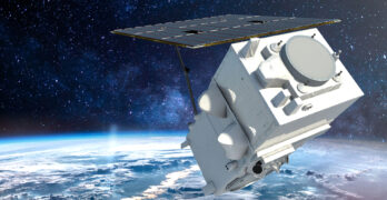
Maxar Intelligence has launched Raptor, a powerful software suite that enables autonomous drones to navigate and extract accurate ground coordinates in the absence of GPS. This technology transforms the resilience […]
HERE expands partnership with Maxar Intelligence to scale automated mapmaking

Maxar Intelligence has expanded their partnership with HERE Technologies to enhance the accuracy, freshness and automation of HERE’s mapmaking process. HERE has been a pioneer in digital mapping for nearly […]
Maxar Intelligence announces new leadership appointments
Maxar Intelligence, a provider of secure, precise, geospatial insights, has appointed Matt Santangelo as Chief Financial Officer (CFO) and Matt Jenkins as Chief Space Systems Officer (CSSO), following the addition […]
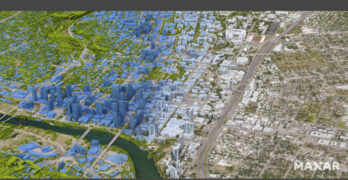
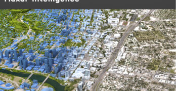
Maxar Intelligence’s first images from next-generation WorldView Legion satellites

Maxar Intelligence, a provider of secure, precise geospatial intelligence, released the first images from its next-generation WorldView Legion satellites, the first two of which were launched from Vandenberg Space Force […]
Maxar Intelligence + Lockheed Martin Expand Partnership
Maxar Intelligence has entered into a long term agreement with Lockheed Martin to streamline the procurement and delivery of Maxar’s geospatial products for the F-35 Full Mission Simulator (FMS) flight […]