
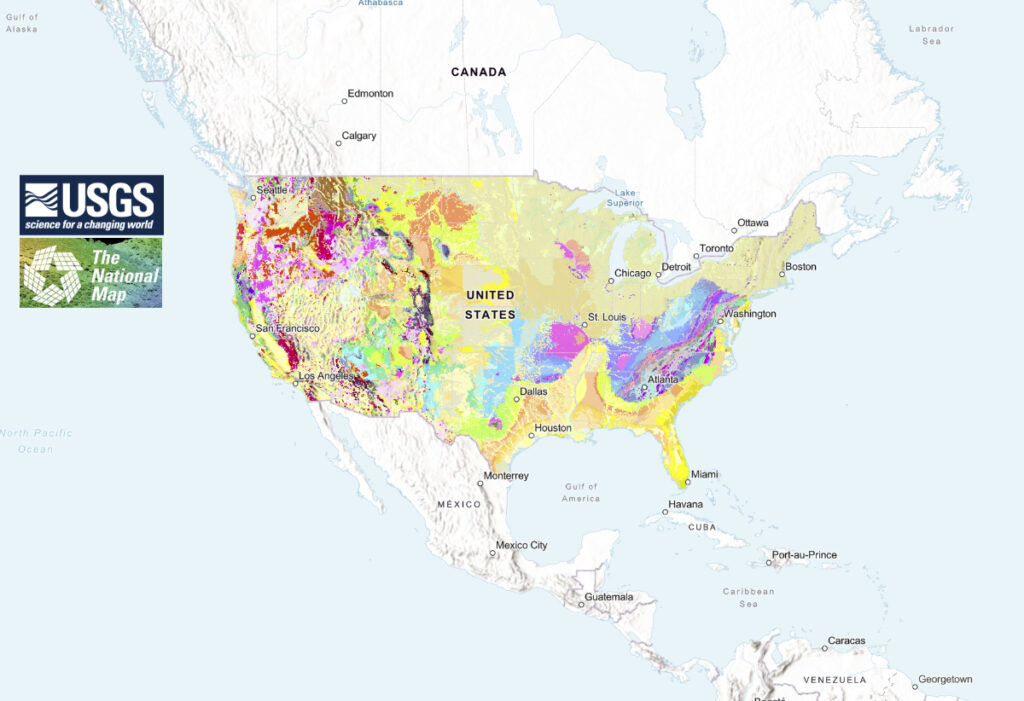
The U.S. Geological Survey has released the most detailed national-scale geologic map of the country (USA) to date, offering a unique, regional view of geology at, and beneath, the Earth’s surface.
Geologic maps use different colors to show various types of rocks and sediments beneath the surface. These are organized into geologic map units, which range in composition from loose sand and gravel to very old bedrock. Each unit has its own unique characteristics, such as age and composition.
The new USGS map, called The Cooperative National Geologic Map, was created using more than 100 preexisting geologic maps from various sources and is the first nationwide map to provide users with access to multiple layers of geologic data for one location. This feature allows users to access the multiple data sources included in the map to look at or beneath the surface to understand the ancient history of the nation recorded in rocks.
These layers can offer new insights into the geology of the nation, enabling more efficient analysis of natural hazards and geologic resources, such as potential focus areas for critical minerals vital to national security and economic development. Currently, the map covers the lower 48 States, but plans are underway to add content for Alaska, Hawaii, and the U.S. territories.
The new interactive web tool was designed to be as user friendly as possible, making it accessible to both geologists and the public. Users can search for specific properties of geologic units or click on the map for additional geologic information and links to more detailed maps of local areas.
In addition to public use, it is anticipated that primary users of the map will include federal agencies, private industries, and educational institutions. A recent cost-benefit study highlighted the usefulness of geologic maps with its findings that the value of geologic maps is up to 10 times greater than the cost of their production.
A key breakthrough in this mapping project was the development of a faster, mostly automated solution that efficiently combines geologic maps from State Geological Surveys and the USGS. Using this new method, USGS experts successfully generated the Cooperative National Geologic Map and an interactive Web interface after only three years of development, a fraction of the time needed to create a map of this scale using traditional methods.
The success of this project is rooted in long-standing collaboration with state geological surveys, according to Dave Soller, senior program scientist for the USGS National Geologic Map Database. He noted that these partnerships have been instrumental in building stronger alliances and advancing more efficient methods for geologic mapping and data dissemination across the nation.
To access the map, visit The Cooperative National Geologic Map website and explore the geological features of the nation. Development of the website and integration of this new product into the national archive was led by the National Geologic Map Database. The geologic data layers, and links to the accompanying report and geospatial services, are found at the National Geologic Map Database landing page for this new publication.
Geologic maps have many uses, such as helping experts look for energy, mineral and water resources,” said Christopher Swezey, USGS National Cooperative Geologic Mapping Program coordinator. “ʼ.”
This map provides complete, analysis-ready geologic data for the nation, in a format that is easy to expand going forward,” said Joseph Colgan, a USGS research geologist and leader of the team that created the map. “By providing this map online, we aim to enhance educational engagement and foster a greater public appreciation of geology.”
Ongoing mapping efforts continually make new discoveries, but past national maps took decades to create while our new method allows us to update our national map faster than ever possible before,” said Sam Johnstone, a USGS research geologist and lead developer for the mapping project.