• Skip to primary navigation
  • Skip to main content
  • Skip to primary sidebar
  • Skip to secondary sidebar
  • NEWS:
  • SatNews
  • SatMagazine
  • MilSatMagazine
  • SmallSat News
  • |     EVENTS:
  • SmallSat Symposium
  • Satellite Innovation
  • MilSat Symposium

SatNews

  • HOME
  • Magazines
  • Events
  • SmallSat Symposium Updates
  • Industry Calendar
    • IN PERSON
    • VIRTUAL
  • Subscribe

Maxar launches Raptor software that unlocks GPS resilience for autonomous systems

March 26, 2025

Maxar Intelligence has launched Raptor, a powerful software suite that enables autonomous drones to navigate and extract accurate ground coordinates in the absence of GPS.
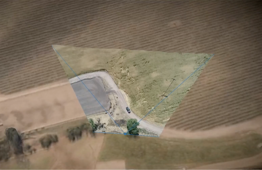
This image shows a drone’s full motion video feed overlaid against Maxar’s highly accurate 3D terrain data, representing the real-time data fusion that’s happening with Raptor Sync. Every coordinate in the drone’s field of view is correlated with its exact position in the real-world with a demonstrated accuracy of within 3 meters of its real-world position.

This technology transforms the resilience and reliability of unmanned systems, enabling autonomy at scale across warfighting, humanitarian and commercial operations for customers across the world.

Designed for lightweight integration with any autonomous platform, Raptor products use only a drone’s native camera and Maxar’s 90 million-plus sq. km. of global 3D terrain data to help the platform navigate with extreme precision and extract accurate ground coordinates in real-time without GPS. Raptor can also operate at night and in low-terrain environments. No additional hardware is required.
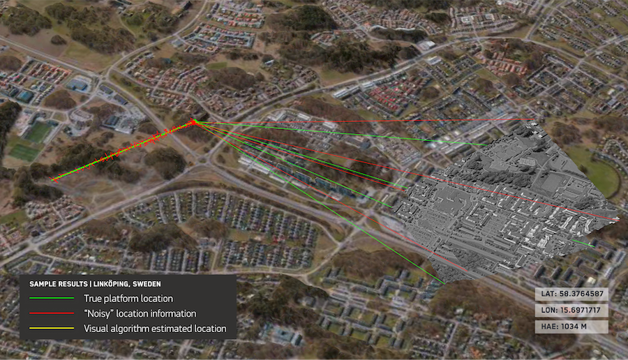
This image shows how Raptor Guide enables an autonomous system to navigate with precision even without GPS. The green line represents the drone’s true location in the real world on a specific flight path. The red line shows the location information sent by the drone without GPS and without using Guide. The yellow line shows the location information sent by the drone when using Raptor Guide without GPS. You can see it delivers a far more accurate reading with Raptor Guide, which would ensure that the platform is navigating with more precision.
The image above shows how Raptor Guide enables an autonomous system to navigate with precision even without GPS. The green line represents the drone’s true location in the real world on a specific flight path. The red line shows the location information sent by the drone without GPS and without using Guide. The yellow line shows the location information sent by the drone when using Raptor Guide without GPS. You can see it delivers a far more accurate reading with Raptor Guide, which would ensure that the platform is navigating with more precision.

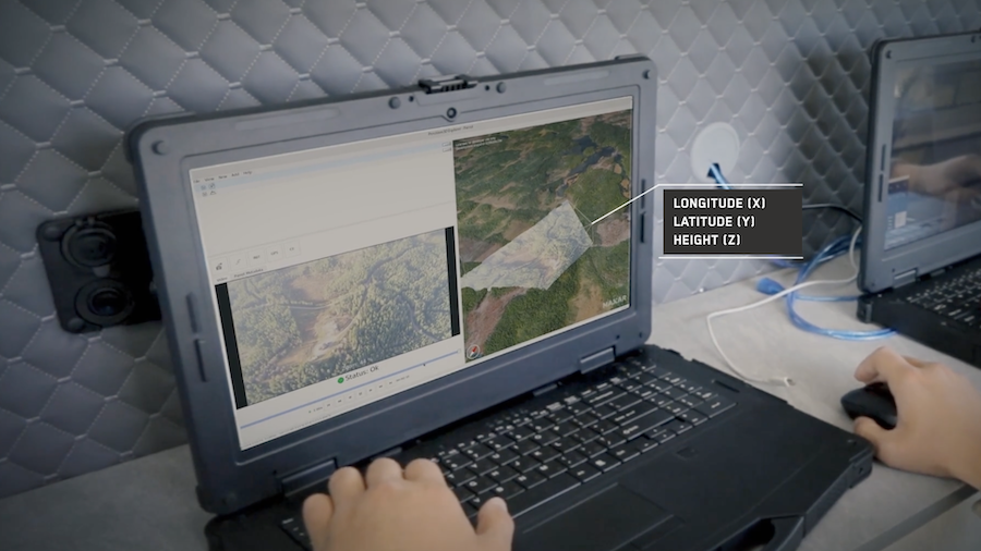
This image shows the Raptor Ace software in action. On the left, the operator sees the live feed from the drone’s native camera. On the right, they see Maxar’s 3D global terrain data. The operator is able to use these two views to select and extract highly accurate coordinates for objects on the ground with a demonstrated accuracy of within 3 meters of its real-world position.

The Raptor suite of software solutions includes:

  • Raptor Guide: Vision-based positioning software loaded directly onto an autonomous platform to determine its aerial position at a demonstrated absolute accuracy of <10 m RMSE.
  • Raptor Sync: Software that georegisters the full motion video feed from the drone’s on-board camera with Maxar’s 3D terrain data in real-time, enabling intelligence fusion, multi-domain interoperability across different sensors and accurate ground coordinate extraction at a demonstrated absolute accuracy of <3 m.
  • Raptor Ace: Software solution installed on commodity laptop equipment that works alongside drone controllers, enabling operators to extract real-time target ground coordinates from full-motion aerial video feeds with a demonstrated absolute accuracy of <3 m.

Raptor represents a fundamentally new solution on the market, providing significant advantages over most visual-based navigation alternatives:

  • Cost- and power-efficient: Raptor software products are deployable on off-the-shelf hardware and require minimal initial integration. Alternative navigation solutions typically require additional hardware.
  • Delivers against complex mission profiles: Built on a true 3D representation of the operational terrain, Raptor products operate at night, in any season, and at altitudes as low as 120 m. Maxar’s 3D global terrain data is regularly updated.
  • Enables autonomy at scale: Because Raptor software anchors sensor data against a common geospatial foundation and works with existing drone cameras, the technology makes it possible for different unmanned systems to work together for joint operations regardless of the software or hardware platform.
  • Works on existing cameras: A dedicated downward-facing camera consumes precious payload space and adds to the platform’s weight and power consumption. Raptor software works with the UAS’s existing optics, including both forward and side-looking cameras.

By eliminating reliance on GPS, Raptor software unlocks the full potential of autonomous systems—from powering truly joint multi-domain operations as part of a digital battlefield to large-scale delivery systems in urban areas where knowing the precise coordinates of your drop-off location is critical to getting the job done,” said Peter Wilczynski, Chief Product Officer at Maxar Intelligence. “Raptor will change the game for customers across the defense and commercial sectors. This software uses Maxar’s unique 3D global terrain data to ensure that autonomous systems get the job done no matter how much GPS interference they face.”

Filed Under: , an Earth Observation (EO) satellite for the Satellite Technology Research Center (SaTReC), Autonomous Drones, Drones, Imagery, Maxar, Maxar Intelligence, Raptor™ (Maxar Intelligence), Software, Software Solutions, Tactical Imagery

Primary Sidebar

Most Read Stories

  • In Their Honor ... Lest We Forget
  • Russian satellite tumbling out of control
  • INNOSPACE signs strategic MoU with Saturn Satellite Networks to develop + launch smallsats
  • Rocket Lab partners with U.S.A.F. | AFRL for Neutron launch for rocket cargo missions
  • ULA's Atlas 5 is ready but is the weather at the Cape ready for Amazon's Project Kuiper launch?

About Satnews

  • Contacts
  • History

Archives

  • June 2025
  • May 2025
  • April 2025
  • March 2025
  • February 2025
  • January 2025
  • December 2024
  • November 2024
  • October 2024
  • September 2024
  • August 2024
  • July 2024
  • June 2024
  • May 2024
  • April 2024
  • March 2024
  • February 2024
  • January 2024
  • December 2023
  • November 2023
  • October 2023
  • September 2023
  • August 2023
  • July 2023
  • June 2023
  • May 2023
  • April 2023
  • March 2023
  • February 2023
  • January 2023
  • December 2022
  • November 2022
  • October 2022
  • September 2022
  • August 2022
  • July 2022
  • June 2022
  • May 2022
  • April 2022
  • March 2022
  • February 2022
  • January 2022
  • December 2021
  • November 2021
  • October 2021
  • September 2021
  • August 2021
  • July 2021
  • June 2021
  • May 2021
  • April 2021
  • March 2021
  • February 2021
  • January 2021
  • December 2020
  • November 2020
  • October 2020
  • September 2020
  • August 2020
  • July 2020
  • June 2020
  • May 2020
  • April 2020

Secondary Sidebar

We use cookies to ensure that we give you the best experience on our website. If you continue to use this site we will assume that you are happy with it.OkPrivacy policy
x
Sign up Now (For Free)
Access daily or weekly satellite news updates covering all aspects of the commercial and military satellite industry.
Invalid email address
Notify Me Regarding ( At least one ):
We value your privacy and will not sell or share your email or other information with any other company. You may also unsubscribe at anytime.

Click Here to see our full privacy policy.
Thanks for subscribing!