• Skip to primary navigation
  • Skip to main content
  • Skip to primary sidebar
  • Skip to secondary sidebar
  • NEWS:
  • SatNews
  • SatMagazine
  • MilSatMagazine
  • SmallSat News
  • |     EVENTS:
  • SmallSat Symposium
  • Satellite Innovation
  • MilSat Symposium
  • SmallSat Europe

SatNews

  • LATEST
  • EXPLORE ⌄
    • Missions & Constellations
    • Business & Finance
    • Military & Defense
    • Launch
    • Software Automation & Ground Systems
    • Government & Regulation
    • Services & Applications
  • Magazines
  • Events
  • Calendar ⌄
    • IN PERSON
    • VIRTUAL
  • Subscribe

Synspective succeeds in test observation of daily InSAR images

June 5, 2024

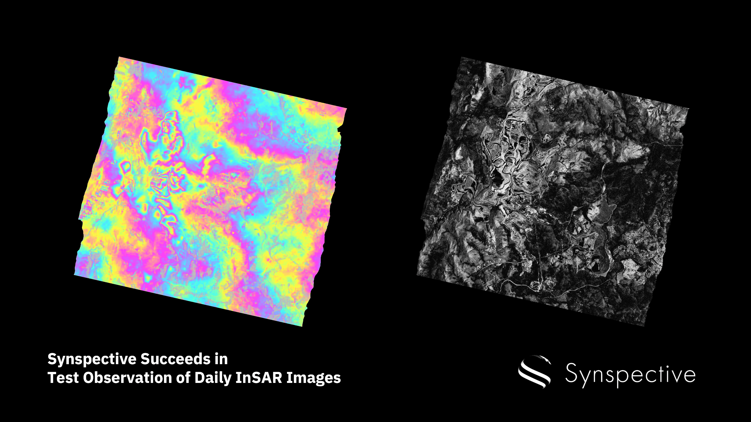
Synspective Inc. has successfully tested observation of images for daily Interferometric Synthetic Aperture (InSAR) analysis with StriX-3, launched in March of 2024, and StriX-1, launched in September of 2022.

InSAR is a technique that detects changes in the Earth’s surface, including surface deformation, terrain height, and other minute movements with millimeter-scale accuracy. It achieves this by applying sophisticated processing to SAR images captured at different times to provide high-resolution data. This technique is capable of penetrating clouds and works in all weather conditions. Recently, several such images were acquired.

The company’s InSAR analysis used two-time pair images from consecutive days in the images below. The colored images show the difference in the phase of the SAR images through color changes, while the monochrome images indicate the coherence of the phase by brightness. High coherence is evident across the entire image. Further analysis can detect topographic data and millimeter-level displacement.

Large SAR satellites currently acquire images at intervals of up to six days. Acquiring images more frequently will significantly expand applications, such as safety management at construction sites and disaster prediction.

Synspective has been selected by the Ministry of Economy, Trade and Industry (METI) for the Small and Medium Business Innovation Research Promotion Project (SBIR Phase 3). The firm will continue to develop technologies and establish a system for the stable provision of daily InSAR images. In addition, InSAR analysis services will continue to be developed, including the Land Displacement Monitoring (LDM) solution.

Filed Under: Earth Observation & Imaging, International Space Agreements

Primary Sidebar

Coverage

  • Missions & Constellations
  • Business & Finance
  • Military & Defense
  • Launch
  • Software Automation & Ground Systems
  • Government & Regulation
  • Services & Applications

Most Read Stories

  • Proximus Global + Starlink to expand Direct-to-Cell satellite connectivity in Europe
  • FCC Opens Review for SpaceX’s 15,000-Satellite VLEO Constellation
  • Congress desires LEO, but threats are real
  • Rohde & Schwarz acquires stake in Orbint GmbH for signal intelligence + reconnaissance from space
  • USSF Awards Initial 'Golden Dome' Prototype Contracts, Signaling Strategic Shift to Space-Based Defense

About Satnews

  • Contacts
  • History

Archives

Secondary Sidebar

We use cookies to ensure that we give you the best experience on our website. If you continue to use this site we will assume that you are happy with it.
x
Sign up Now (For Free)
Access daily or weekly satellite news updates covering all aspects of the commercial and military satellite industry.
Invalid email address
Notify Me Regarding ( At least one ):
We value your privacy and will not sell or share your email or other information with any other company. You may also unsubscribe at anytime.

Click Here to see our full privacy policy.
Thanks for subscribing!