• Skip to primary navigation
  • Skip to main content
  • Skip to primary sidebar
  • Skip to secondary sidebar
  • NEWS:
  • SatNews
  • SatMagazine
  • MilSatMagazine
  • SmallSat News
  • |     EVENTS:
  • SmallSat Symposium
  • Satellite Innovation
  • MilSat Symposium
  • SmallSat Europe

SatNews

  • LATEST
  • EXPLORE ⌄
    • Missions & Constellations
    • Business & Finance
    • Military & Defense
    • Launch
    • Software Automation & Ground Systems
    • Government & Regulation
    • Services & Applications
  • Magazines
  • Events
  • Calendar ⌄
    • IN PERSON
    • VIRTUAL
  • Subscribe

Synspective + Dynamic Map Platform selected for Enterprise Innovation Promotion Program

February 28, 2024

Synspective Inc. (Synspective) and Dynamic Map Platform Co., Ltd. (Dynamic Map Platform) have been selected by the Japanese Ministry of Land, Infrastructure, Transport and Tourism for the Small and Medium Enterprise Innovation Promotion Program.

With the Dynamic Map Platform, Synspective submitted a proposal entitled  “Improving road management efficiency by increasing the accuracy of location information using SAR data based on HD maps.” The committee selected our proposal under the “Development of technologies that contribute to the advancement of road management monitoring and observation using next-generation technologies” category, awarding the company a grant of up to 350 million yen for the eligible project.

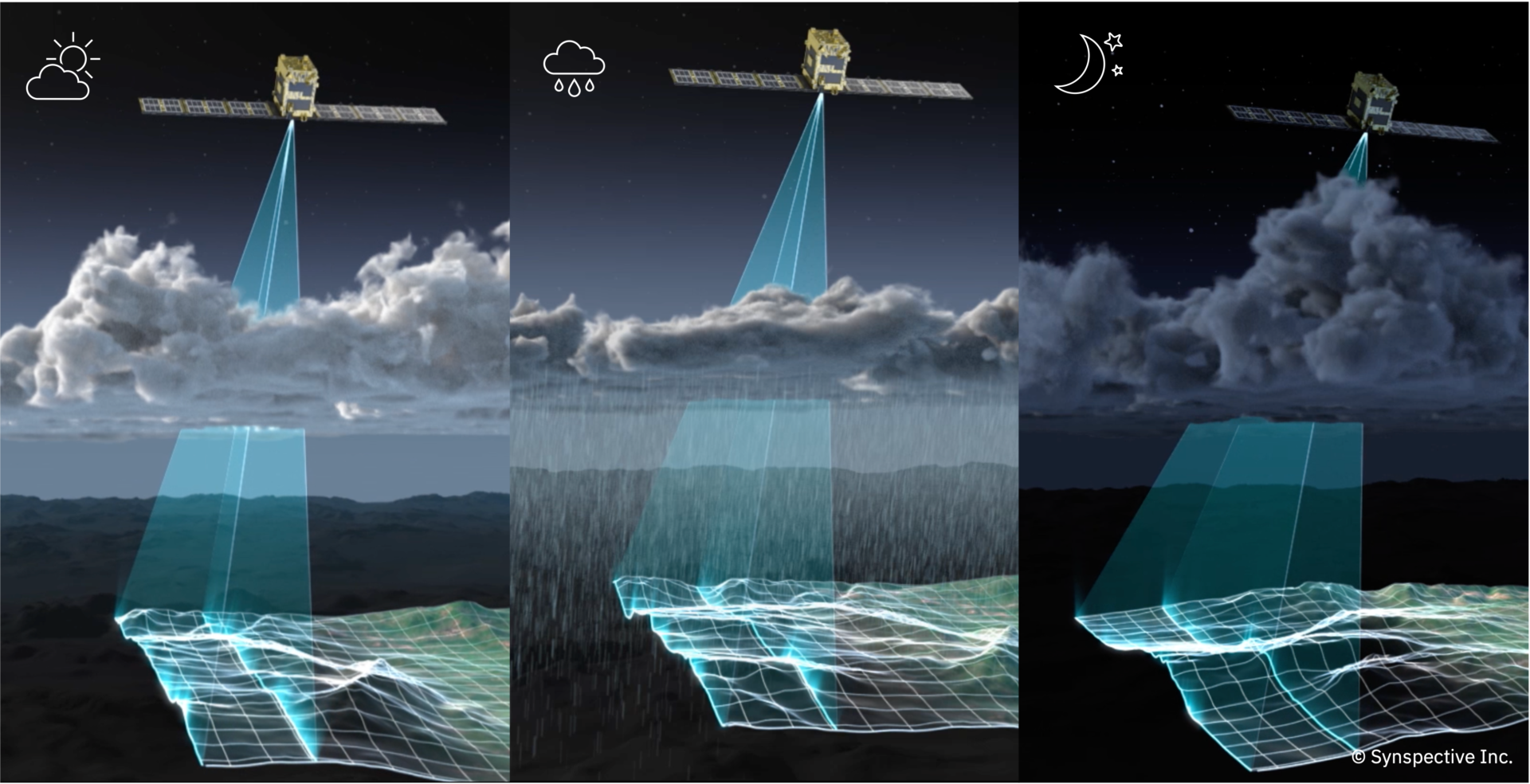
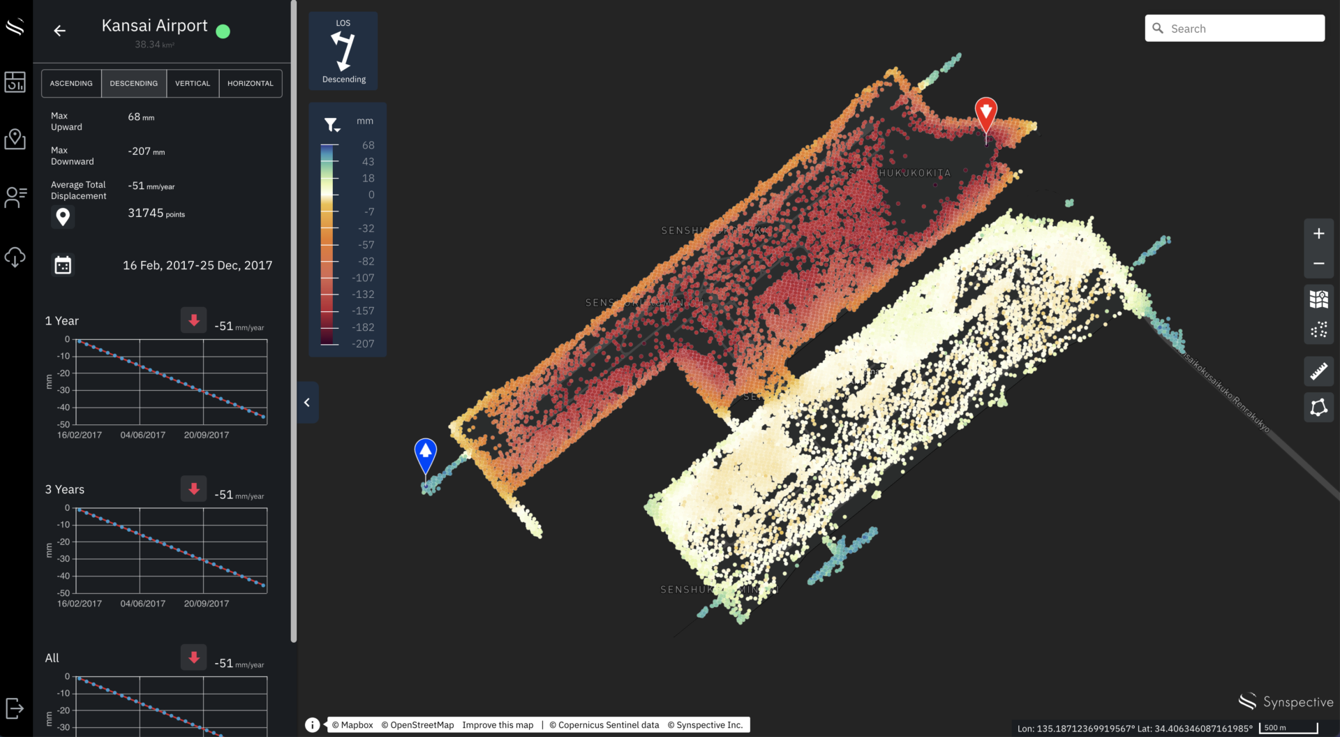
This project leverages SAR satellite technologies and Synspective’s Land Displacement Monitoring (LDM) solution and aims to integrate these technologies with HD maps for autonomous driving, which provide high-precision 3D positioning data. The focus will be on studying how this data can be applied to enhance road infrastructure management.

During development, Synspective will use HD maps to achieve high positional accuracy of SAR data and develop data sets that will support road infrastructure monitoring and maintenance. A data linkage system and viewer will be created that are designed for road maintenance and management. This setup will facilitate the visualization of disaster conditions and enable data sharing through API integration with other systems to advance road infrastructure management.

© Mapbox © OpenStreetMap Improve this map | © Copernicus Sentinel data [2014-2023] | © Synspective Inc.

Filed Under: Earth Observation & Imaging, International Space Agreements

Primary Sidebar

Coverage

  • Missions & Constellations
  • Business & Finance
  • Military & Defense
  • Launch
  • Software Automation & Ground Systems
  • Government & Regulation
  • Services & Applications

Most Read Stories

  • Brian Cox Addresses Interstellar Comet Signal Claims Amid MAVEN Silence
  • U.S. Space Force and SpaceX Partner to Develop 480-Satellite MILNET Constellation
  • When AWS Grew Wings: The "Boring" Genius of Amazon Leo
  • AT&T, AST SpaceMobile Advance Satellite-to-Cell Expansion Following BlueBird 6 Deployment
  • SpaceRISE Consortium Initiates Procurement for IRIS² Satellite and Launch Services

About Satnews

  • Contacts
  • History

Archives

Secondary Sidebar

We use cookies to ensure that we give you the best experience on our website. If you continue to use this site we will assume that you are happy with it.
x
Sign up Now (For Free)
Access daily or weekly satellite news updates covering all aspects of the commercial and military satellite industry.
Invalid email address
Notify Me Regarding ( At least one ):
We value your privacy and will not sell or share your email or other information with any other company. You may also unsubscribe at anytime.

Click Here to see our full privacy policy.
Thanks for subscribing!