• Skip to primary navigation
  • Skip to main content
  • Skip to primary sidebar
  • Skip to secondary sidebar
  • NEWS:
  • SatNews
  • SatMagazine
  • MilSatMagazine
  • SmallSat News
  • |     EVENTS:
  • SmallSat Symposium
  • Satellite Innovation
  • MilSat Symposium
  • SmallSat Europe

SatNews

  • LATEST
  • EXPLORE ⌄
    • Missions & Constellations
    • Business & Finance
    • Military & Defense
    • Launch
    • Software Automation & Ground Systems
    • Government & Regulation
    • Services & Applications
  • Magazines
  • Events
  • Calendar ⌄
    • IN PERSON
    • VIRTUAL
  • Subscribe

RTX space sensor to monitor coastal ecosystem health

August 14, 2023

Raytheon, an RTX (NYSE: RTX) business, has announced that the company’s Geostationary Littoral Imaging and Monitoring Radiometer (GLIMR) sensor has completed its Critical Design Review (CDR) and is now in the build and test phase of the program.

NASA selected GLIMR to be the agency’s first, hyperspectral imager in GEO. GLIMR will collect and process information from across the electromagnetic spectrum, including visible light, infrared and ultraviolet frequencies, to create a highly detailed view of physical and biological conditions in coastal waters.

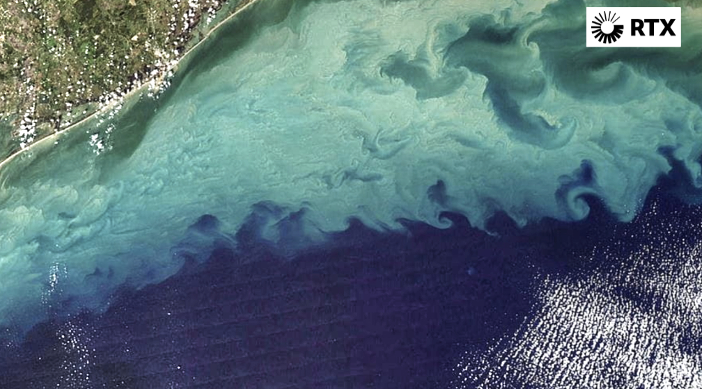
The instrument will provide high-sensitivity, high-spatial and high-temporal resolution measurements of coastal and ocean ecosystems in the Gulf of Mexico, parts of the southeastern U.S. coastline and the Amazon River plume. Decision-makers will use GLIMR data to respond rapidly to natural and manmade coastal water disasters, such as harmful algae blooms and oil spills. It will also help improve the coastal ecosystem’s sustainability and resource management.

Raytheon also recently completed their final review for NOAA’s Geostationary Extended Observations satellite system (GeoXO) and is taking lessons learned from the GLIMR to design the nexgen, operational, weather satellite payload that will launch in 2032.

The University of New Hampshire is NASA’s lead organization for the GLIMR contract, led by principal investigator Dr. Joseph Salisbury, with a team of scientists from partnering universities, as well as NOAA and NASA. The instrument will launch in the 2026-2027 timeframe and its data will be available soon after to scientists, researchers and educators around the world. Work for both programs is being executed in El Segundo, California.

“GLIMR will help enable us to better study our planet’s oceans. With this new capability, we’ll be able to better track coral bleaching, chlorophyl and plankton health, oil spills and Harmful Algal Blooms, otherwise known as red tide.” — David Broadbent, President of Space Systems, Raytheon

Filed Under: Business & Finance, Climate & Environmental Monitoring

Primary Sidebar

Coverage

  • Missions & Constellations
  • Business & Finance
  • Military & Defense
  • Launch
  • Software Automation & Ground Systems
  • Government & Regulation
  • Services & Applications

Most Read Stories

  • Brian Cox Addresses Interstellar Comet Signal Claims Amid MAVEN Silence
  • U.S. Space Force and SpaceX Partner to Develop 480-Satellite MILNET Constellation
  • When AWS Grew Wings: The "Boring" Genius of Amazon Leo
  • AT&T, AST SpaceMobile Advance Satellite-to-Cell Expansion Following BlueBird 6 Deployment
  • SpaceRISE Consortium Initiates Procurement for IRIS² Satellite and Launch Services

About Satnews

  • Contacts
  • History

Archives

Secondary Sidebar

We use cookies to ensure that we give you the best experience on our website. If you continue to use this site we will assume that you are happy with it.
x
Sign up Now (For Free)
Access daily or weekly satellite news updates covering all aspects of the commercial and military satellite industry.
Invalid email address
Notify Me Regarding ( At least one ):
We value your privacy and will not sell or share your email or other information with any other company. You may also unsubscribe at anytime.

Click Here to see our full privacy policy.
Thanks for subscribing!