• Skip to primary navigation
  • Skip to main content
  • Skip to primary sidebar
  • Skip to secondary sidebar
  • NEWS:
  • SatNews
  • SatMagazine
  • MilSatMagazine
  • SmallSat News
  • |     EVENTS:
  • SmallSat Symposium
  • Satellite Innovation
  • MilSat Symposium
  • SmallSat Europe

SatNews

  • LATEST
  • EXPLORE ⌄
    • Missions & Constellations
    • Business & Finance
    • Military & Defense
    • Launch
    • Software Automation & Ground Systems
    • Government & Regulation
    • Services & Applications
  • Magazines
  • Events
  • Calendar ⌄
    • IN PERSON
    • VIRTUAL
  • Subscribe

Airbus Completes 2nd Ocean Satellite Sentinel-6B

December 5, 2021

Sentinel-6B loaded in a container for shipment. Image is courtesy of Airbus / T. Locher.


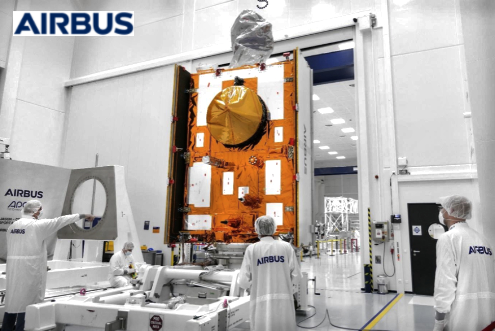
Airbus has completed Sentinel-6B, the second ocean monitoring satellite of the European Copernicus program and is now testing it extensively over the next six months in preparation for its use in space.

The Copernicus Sentinel-6 mission is already delivering high-precision measurement of the topography of ocean surfaces through the first of two satellites, Sentinel-6A, launched in November of 2020. The mission’s two satellites are built to measure the distance to the sea surface to an accuracy of a few centimeters and map it in a 10-day rhythm over a mission duration of up to seven years. Their purpose is to record changes in the height of the sea surfaces, variations in sea levels and analyze and observe ocean currents.

Accurate observation of sea surface height changes provides information about global sea levels, the speed and direction of ocean currents and the heat stored in the oceans. The measurements — obtained from 1,336 km. above the Earth — are crucial for ocean modelling and predicting sea level rise. This information helps governments and institutions to establish effective protection for coastal regions. The data is also valuable for disaster management organizations, and for authorities carrying out urban planning, flood protection schemes, or dyke construction.

Global sea levels are currently rising by an average of 3.3 millimeters per year, with potentially dramatic consequences for countries with densely populated coasts.

Part of Europe’s Copernicus, Sentinel-6 is also an international collaboration between ESA, NASA, NOAA and Eumetsat.

Artistic rendition of Sentinel-6B on-orbit. Image is courtesy of ESA.

Filed Under: Climate & Environmental Monitoring, Earth Observation & Imaging

Primary Sidebar

Coverage

  • Missions & Constellations
  • Business & Finance
  • Military & Defense
  • Launch
  • Software Automation & Ground Systems
  • Government & Regulation
  • Services & Applications

Most Read Stories

  • MDA Adds 340 Vendors to $151 Billion SHIELD Enterprise in Third Major Tranche
  • As SpaceX Targets 50,000 Starlink Satellites, China Files for 200,000-Unit Mega-Constellation
  • Rivada Space Networks: Time for an announcement?
  • Amentum Mitie Pacific Wins $656M Contract for Strategic Space Hub at Diego Garcia
  • SpaceX IPO Speculation Peaks as Analysts Weigh 2026 Valuation and Strategic Consolidation

About Satnews

  • Contacts
  • History

Archives

Secondary Sidebar

We use cookies to ensure that we give you the best experience on our website. If you continue to use this site we will assume that you are happy with it.
x
Sign up Now (For Free)
Access daily or weekly satellite news updates covering all aspects of the commercial and military satellite industry.
Invalid email address
Notify Me Regarding ( At least one ):
We value your privacy and will not sell or share your email or other information with any other company. You may also unsubscribe at anytime.

Click Here to see our full privacy policy.
Thanks for subscribing!