• Skip to primary navigation
  • Skip to main content
  • Skip to primary sidebar
  • Skip to secondary sidebar
  • NEWS:
  • SatNews
  • SatMagazine
  • MilSatMagazine
  • SmallSat News
  • |     EVENTS:
  • SmallSat Symposium
  • Satellite Innovation
  • MilSat Symposium

SatNews

  • HOME
  • Magazines
  • Events
  • SmallSat Symposium Updates
  • Industry Calendar
    • IN PERSON
    • VIRTUAL
  • Subscribe

The First Light Images From Landsat 9 Are Released By NASA

November 7, 2021

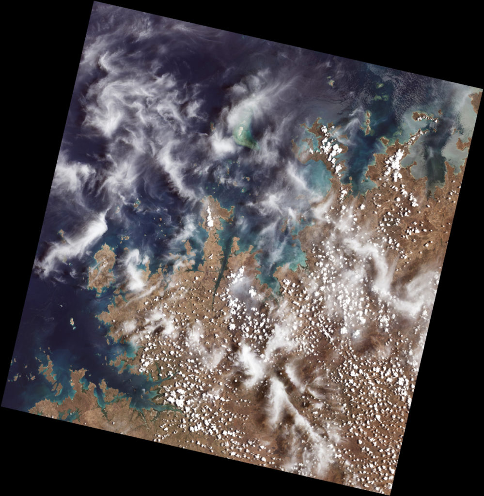
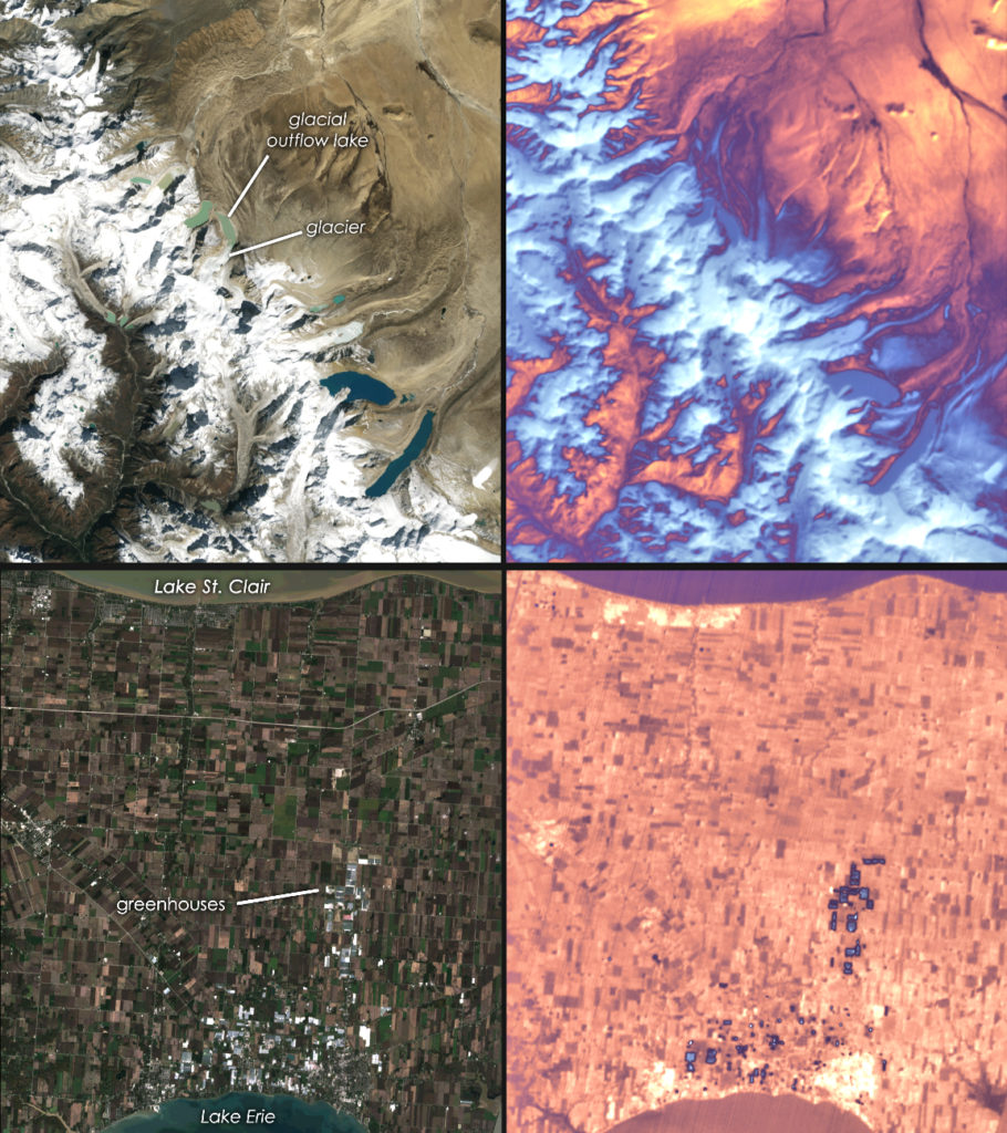
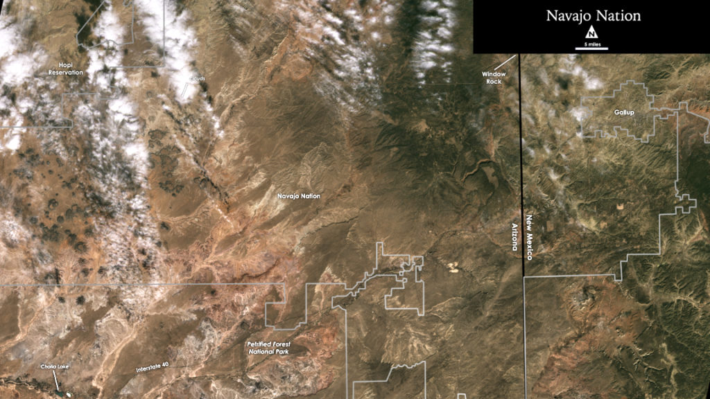
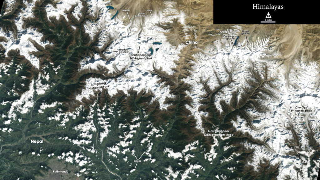
Landsat 9, a joint mission from NASA and the U.S. Geological Survey, was launched on September 27, 2021, and has now collected its first images of Earth. These images, all acquired on October 31, 2021, provide a preview of how the mission will help people manage vital natural resources and track the impacts of climate change, adding to Landsat’s data record that spans nearly 50 years of space-based Earth Observation (EO).

Landsat 9 carries two instruments that capture imagery: the Operational Land Imager 2, or OLI-2, which detects nine different wavelengths of visible, near-infrared and shortwave-infrared light; and the Thermal Infrared Sensor 2, or TIRS-2, which detects two wavelengths of thermal radiation to measure slight changes in temperature. These instruments will provide Landsat 9 users essential information about crop health, irrigation use, water quality, wildfire severity, deforestation, glacial retreat, urban expansion and more.

Ball Aerospace’s OLI-2 imager.

OLI-2 was built by Ball Aerospace .

TIRS-2 was built by NASA’s Goddard Space Flight Center. Northrop Grumman.

Landsat 9 spacecraft, integrated it with the instruments, and tested the observatory.

NASA’s Landsat 9 team is in the midst of a 100-day check-out period, which involves testing the satellite’s different systems and subsystems and calibrating the instruments in preparation for handing the mission over to the USGS in January. The USGS will operate Landsat 9 along with Landsat 8, and together the two satellites will collect approximately 1,500 images of Earth’s surface every day, covering the globe every eight days.

The first data from Landsat 9, of Australia’s Kimberley Coast in Western Australia, shows off the capabilities of the two instruments on the spacecraft. This image, from the Operational Land Imager 2, or OLI-2, was acquired on Oct. 31, 2021. Although similar in design to its predecessor Landsat 8, the improvements to Landsat 9 allow it to detect more subtle differences, especially over darker areas like water or the dense mangrove forests along the coast.

Landsat 9 data will be available to the public, for free, from USGS’s website, as soon as the satellite begins normal operations.

Landsat 9’s two instruments are designed to work together to capture a broad range of wavelengths: OLI-2 detects nine different wavelengths of visible, near-infrared and shortwave-infrared light; and TIRS-2 detects two wavelengths of thermal radiation to measure slight changes in temperature. Data from both instruments are shown in the two pairs in this image. The top left shows snow and glaciers in the Himalayan mountains, leading to the flat Tibetan Plateau to the north. The top right shows the same area in thermal data from the TIRS-2 instrument. Blue-white color indicates relatively cooler surface temperatures, while orange-red indicates warmer surface temperatures.The bottom left shows the brown and green rectangles of farm fields in southern Ontario, sandwiched between Lake Erie and Lake St. Clair. The white and grey rectangles in the bottom of the image are produce greenhouses, which show up as blue-ish (relatively cooler) spots in the TIRS-2 image on the right.
The white sands of Pensacola Beach stand out in this Landsat 9 image of the Florida Panhandle of the United States, with Panama City visible under some popcorn-like clouds. Landsat and other remote sensing satellites help to track changes to US coastlines, including urban development and potential impacts of rising sea levels. From Oct. 31, 2021, the first day of data collection for Landsat 9.
Sediments swirl in Lake Erie and Lake St. Clair in this Landsat 9 image of both Detroit, Michigan, and Windsor, Ontario, from Oct. 31, 2021. The Great Lakes serve as sources of freshwater, recreational activity, transport, and habitat for the upper-midwestern US, and water quality remains a high priority. In warmer months, Landsat 9 observes swirls of green algae which can become harmful algal blooms. Landsat 9 will be able to help scientists and resource managers identify those blooms early, identifying areas to test further.
The Dry Southwest U.S. — In the Western U.S., in places like the Navajo Nation as seen in this Landsat 9 image, Landsat and other satellite data helps people monitor crop health and help manage irrigation water. With only 85 rain gauges to cover more than 27,000 square miles, satellite data and climate models are filling the gaps to help the Navajo Nation monitor drought severity.
The Himalayas — The city of Kathmandu, Nepal, seen at the bottom left of this Landsat 9 image, lies in a valley south of the Himalayan Mountains between Nepal and China. Glaciers, and the lakes formed by glacial meltwater, are visible in the top middle of this image. In High Mountain Asia, many communities rely on meltwater from glaciers – and Landsat can help track how those glaciers are changing in a warming climate. Previous studies with Landsat have documented shrinkage of Himalayan glaciers, as well as changing lake levels the adjacent Tibetan plateau. From Oct. 31, 2021, the first day of data collection for Landsat 9.

This article and imagery is courtesy of NASA’s Goddard Space Flight Center, using data from the U.S. Geological Survey.

Filed Under: Agencies, Imagery, Instruments, News, Satellites

Primary Sidebar

Most Read Stories

  • ULA's Amazon Project Kuiper now set for April 28 launch
  • ULA plans Amazon Project Kuiper's launch on Monday
  • Rocket Lab confirms D2C ambitions
  • Russian satellite tumbling out of control
  • Vast announces 3 additional payload partners for Haven-1 Lab + signs leverage agreement with ISS National Laboratory

About Satnews

  • Contacts
  • History

Archives

  • May 2025
  • April 2025
  • March 2025
  • February 2025
  • January 2025
  • December 2024
  • November 2024
  • October 2024
  • September 2024
  • August 2024
  • July 2024
  • June 2024
  • May 2024
  • April 2024
  • March 2024
  • February 2024
  • January 2024
  • December 2023
  • November 2023
  • October 2023
  • September 2023
  • August 2023
  • July 2023
  • June 2023
  • May 2023
  • April 2023
  • March 2023
  • February 2023
  • January 2023
  • December 2022
  • November 2022
  • October 2022
  • September 2022
  • August 2022
  • July 2022
  • June 2022
  • May 2022
  • April 2022
  • March 2022
  • February 2022
  • January 2022
  • December 2021
  • November 2021
  • October 2021
  • September 2021
  • August 2021
  • July 2021
  • June 2021
  • May 2021
  • April 2021
  • March 2021
  • February 2021
  • January 2021
  • December 2020
  • November 2020
  • October 2020
  • September 2020
  • August 2020
  • July 2020
  • June 2020
  • May 2020
  • April 2020

Secondary Sidebar

We use cookies to ensure that we give you the best experience on our website. If you continue to use this site we will assume that you are happy with it.OkPrivacy policy
x
Sign up Now (For Free)
Access daily or weekly satellite news updates covering all aspects of the commercial and military satellite industry.
Invalid email address
Notify Me Regarding ( At least one ):
We value your privacy and will not sell or share your email or other information with any other company. You may also unsubscribe at anytime.

Click Here to see our full privacy policy.
Thanks for subscribing!