

Japan International Cooperation Agency (JICA) and Synspective have started a satellite use service demonstration to monitor ground movements in Guatemala City, Guatemala, as part of an information gathering and pilot project.

Guatemala is prone to earthquakes and other disaster risks such as heavy rains due to hurricanes, landslides, and volcanic disasters. Japan, which is also a volcanic country, has been implementing a technical cooperation project for disaster prevention to support the country.
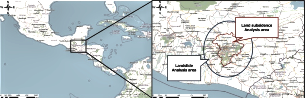
In Guatemala, there is always the risk of subsidence and landslides caused by earthquakes. In the 1970s, the capital was hit by an earthquake that killed thousands of people and injured many others. In 2010, a giant sinkhole about 60 feet wide and 30 stories deep, opened up in the middle of Guatemala City, which consumed a three-story building and an intersection. Additionally, in 2015, a large-scale landslide engulfed a village near the capital killing more than 100 people. There continue to be concerns about the potential danger to urban city life and infrastructure.
In order to understand land displacement risks, land surveying and reference point surveying have been considered, but they can only gather information at each point. Only a portion of surveying projects have been carried out using satellite data with wide-area coverage capabilities. Satellite surveying technology, which requires advanced analytical technologies and specialization, has been limited. It was therefore necessary to develop a system in continuous use with the introduction of satellite survey monitoring to improve disaster prevention capabilities over a wide area.
Contributes to early risk detection Synspective’s “Land Displacement Monitoring (LDM)” is a solutions-based service that is capable of detecting displacement over a wide area. The service provides results for urban cities, including Guatemala City, which is at risk of land displacement and deformation. In August, the company introduced a demonstration with Guatemala’s capital to contribute to efficient survey operations and detect potential risk at latent stages.
Anticipated effects By using LDM, it is possible to identify displacement disasters and take measures to prevent building and home collapse, ensuing financial losses, as well as protect residents. In addition, by introducing a platform service that features analytical results from SAR satellites, the service will lead to disaster monitoring and preventive maintenance through continuous use.
Advantages of LDM and satellite applications SAR satellites can steadily acquire ground information regardless of weather conditions and time zones. Additionally, while existing surveying techniques can only obtain data at each surveying point, SAR satellites make it possible to obtain data even in invisible areas. With the ongoing COVID-19 pandemic, current surveying methods involve social risks such as infection from human contact. Remote surveying can reduce on-site surveying activities and deter the risk and spread of infection, as well as reduce time and travel costs.
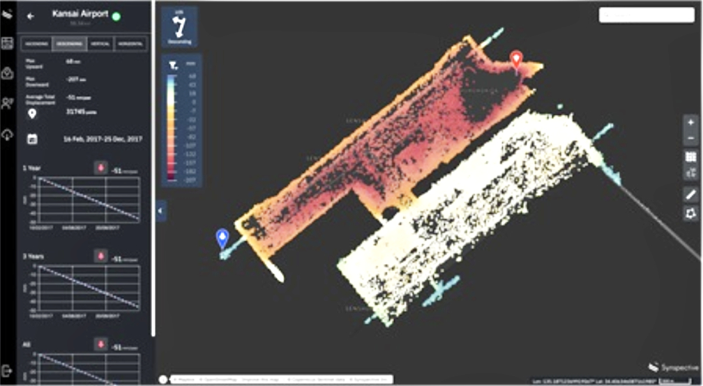
The advantages of LDM are that analysis results from SAR satellites can be easily obtained, and that they can also be provided in an easy-to-understand visual format that does not require specialized software or knowledge. Regarding functionality, it is possible to zoom in on a specified area of interest and automatically generate a graph, enabling detailed data verification and analysis. Demonstration target area Guatemala City and surrounding suburbs
Period of demonstration runs from 08/2021 to 01/2022