

CATALYST, a PCI Geomatics brand, has delivered an automated workflow for the South African National Space Agency’s (SANSA) Earth Observation Department to convert decades of SPOT satellite imagery to CARD4L Analysis Ready Data (ARD).
The scalable workflow enables SANSA to prepare its entire SPOT archive for immediate analysis using the Open Data Cube, machine learning and AI models.
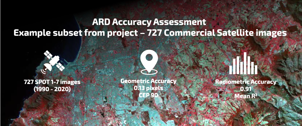
CATALYST’s ARD workflow automatically converts optical satellite imagery into ARD measurements by performing a series of image preprocessing operations. The output product is a geometrically precise image with nbar surface reflectance measurements based on the rigor and specifications of CARD4L.
SANSA is the government agency responsible for South Africa’s space programs and research. The SANSA Earth Observation department collects, processes, archives, and disseminates satellite imagery to support policy and decision making, economic growth, and sustainable development. Imagery in the enormous SANSA SPOT archive is used by multiple government departments for programs related to agriculture, water resource management, and responsible development.

SANSA plans to make their ARD SPOT imagery, which they have been collecting since the early 90s, available to all South African government agencies using the Open Data Cube geospatial data management and analysis platform.
Scientists from various government departments and industries will find that ARD eliminates the significant time and complexities of preparing satellite imagery for analysis, making it more accessible and easier to use. Furthermore, analytical outputs will be more accurate because the ARD process produces geometrically and radiometrically consistent data sets – even if they were collected with different sensors at varying spatial resolutions.
The ARD workflow developed by CATALYST helps to future-proof the investment SANSA has made in acquiring and storing SPOT imagery over the last 30 years. By converting their SPOT archive into CARD4L compliant ARD imagery, SANSA is producing a new commodity that meets the quality and data packaging standards set by the international Committee on Earth Observation Satellites (CEOS). This ensures interoperability among CARD4L image products and a long useful life.
CATALYST is now offering the ARD Workflow within CATALYST Enterprise and CATALYST Microservices for public and commercial satellite optical sensors. The CATALYST Enterprise solution enables users to build scalable production systems for repeatable Earth observation image processing workflows of any size. CATALYST Microservices leverage the infrastructures and business models of public cloud providers to cost effectively process Earth imagery in the cloud at unprecedented scales.