
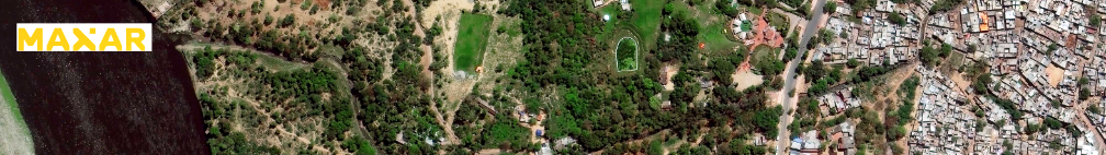
Maxar Technologies (NYSE:MAXR) (TSX:MAXR) has announced that Vricon, Inc., a wholly owned subsidiary of Maxar Technologies, Inc., was awarded Phase 2 of the U.S Army’s One World Terrain (OWT) prototype Other Transaction Agreement (OTA) contract worth $39.3 million.

The OWT program delivers 3D global terrain capability and associated information services that support a fully accessible virtual representation of the physical Earth through the Army network. The original $35.8 million Phase 1 OWT contract was awarded in June 2019 to Vricon, which was acquired by Maxar in July of 2020. If all three phases and options are exercised, the total value of the OWT prototype project is $94.7 million.

OWT is a foundational element of the Synthetic Training Environment-Information System (STE-IS), a modernization initiative led by the STE Cross Functional Team at Army Futures Command (AFC), managed by the Program Executive Office Simulation, Training and Instrumentation (PEO STRI) and contracted through Army Contracting Command-Orlando (ACC-O).
The OWT solution starts with the 3D commercial foundation data layer to create a geo-specific, high-resolution representation that accurately reflects the complexities of operational environments.
Maxar’s Vricon completed OWT Phase 1, which focused on Army training and simulation, in late 2020. Throughout 2021, OWT Phase 2 will shift to a focus on 3D geospatial components across the entire Army, including support of multi-domain operations, mission command systems and other non-training functions.
“Maxar is proud to continue its work with One World Terrain and to provide 3D data and technology in support of Army mission objectives for other very tactical use cases,” said Dan Jablonsky, Maxar CEO. “Beyond essential simulation-ready training data, potential applications for OWT include situational awareness, mission planning, navigation, and targeting. Maxar is committed to offering our 3D terrain capabilities globally across industries as demand increases for a multidimensional, highly accurate digital model of the surface of the Earth.”
Maxar’s WorldView Legion is expected to launch this year and will offer high-resolution, high-accuracy and very high revisit imaging missions.


Additionally, Maxar is partnering with the New Zealand Space Agency to organize the
that will take place over the weekend of April 17-18, 2021. Maxar will grant New Zealand university students access to portions of its vast imagery archive of high-resolution Earth observation data, which includes full coverage over New Zealand dating back almost 20 years.
Access to this data will enable the students to learn from and analyze economic, health and environmental challenges by applying leading-edge analytics, change detection and other creative solutions to develop actionable information.
Second, the parties will explore partnership and supply chain opportunities for New Zealand commercial firms to complement Maxar’s work with NASA.
Third, Maxar and New Zealand will identify and promote STEM-related internship opportunities in Maxar organizations for New Zealand university students with the goals of expanding expertise and experience base for New Zealand space industry and meeting Maxar joint workforce development objectives.
“Maxar is thrilled to embark on this partnership with New Zealand, one of the United States’ most trusted allies,” said Dan Jablonsky, Maxar CEO. “Collaborations such as this have vast potential to foster long-term partnerships, accelerate technology development and cultivate the workforce of tomorrow.”
“Maxar Technologies is a trusted partner and has a history of providing timely, high-resolution satellite imagery to the New Zealand government, and establishing an MOU is an important step in enabling collaboration between our organizations,” said Peter Crabtree, MBIE General Manager of Science, Innovation and International, and Head of the New Zealand Space Agency. “We’re looking forward to hosting the first of several projects with Maxar and exploring new opportunities for collaboration that will benefit New Zealanders.”