
Maxar is expanding their High-Definition (HD) imagery offering with the introduction of 15 cm HD. 15 cm HD provides a new pixel experience for our customers, helping them identify smaller features on the ground to make more informed decisions from satellite imagery.
15 cm HD is created by applying the company’s proprietary HD technology to their native 30 cm imagery. HD technology intelligently increases the number of pixels through a complex mathematical model that is tuned to the specific requirements of our imagery, resulting in a superior visual experience. This innovation will produce well-defined features and help both people and algorithms better extract meaningful information.
Today, 15 cm HD is available for Maxar’s satellite imagery products (View-Ready and Map-Ready products), and it will soon be applied to the firm’s basemap products (Vivid and Dynamic) to provide an improved visual experience throughout our portfolio.
More opportunities with 15 cm HD
The Maxar satellite constellation provides the highest-resolution (natively collected) imagery in the commercial market. About 680,000 sq km of 30 cm imagery is collected every day, providing an abundant inventory to create 15 cm HD. WorldView Legion will triple Maxar’s 30 cm collection capacity, and this significant increase of natively collected content will unleash new opportunities to provide 15 cm HD imagery globally, unlocking additional monitoring, mapping and AI/ML products and services.
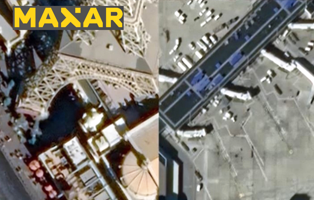
The examples below provide a visual of the details and insights that can be uncovered with 15 cm HD.
Monitoring
15 cm HD significantly expands the level of detail, maximizing the ability to see smaller features that can be gathered from satellite imagery. For customers who need to monitor and identify critical areas, 15 cm HD provides new insights into remote locations to observe high-value assets, environment, agriculture and change over time. Reducing in-field inspections protects both assets and personnel.

Mapping
From large-scale projects to detailed city information, 15 cm HD enables higher-definition mapping with a level of detail that allows governments, organizations and commercial customers to verify features, such as light poles, signs and road and infrastructure conditions, without the inconvenience or cost of sending teams into the field.

AI/ML applications
In our blog “HD Satellite Imagery and Machine Learning,” the company demonstrated how HD technology improves the average precision of the object detection of the ML algorithm. 15 cm HD provides additional detail for automated analysis and feature extraction.

Aerial complement
Aerial customers are already using 15 cm HD to augment their collections over regions that are too remote to fly aircraft and to support aerial mapping missions that have been affected by the pandemic. 15 cm HD is not a replacement for aerial mapping, but augments this solution with global coverage with satellite imagery.

HD next steps
The continued expansion of Maxar’s HD technology helps the company’s customers use this satellite imagery to solve more problems. As the firm prepares to launch Maxar’s upcoming WORLDVIEW LEGION SATELLITES, the value of HD will unlock new insights on Earth.
Learn more about HD and download a 30 cm image sample and the image’s corresponding 15 cm HD image sample.