
With grain exports from the Ukraine under reported dire and continued threat from Russian attacks on the country, pictured here are a pair of SkySat images that were captured by […]
War
Maxar’s Satellite Imagery Brings To Light Additional Damage To The Ukraine By Russian Attack Forces
On May 12th, Maxar collected new satellite imagery of several key locations in southern Ukraine that include Snake Island, Odesa and Mariupol. Snake IslandThis current imagery of the island (located […]
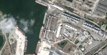
Maxar Captures Mariupol, Ukraine, Imagery Of The Continuing Russian Invasion Of The Country

Maxar collected new high-resolution satellite imagery of Mariupol, Ukraine, as the country continues to battle the Russian invasion. The imagery (collected on April 29th), provides a detailed visual perspective of […]
Maxar’s Satellite Imagery Captures Russian Redeployments + Offensive Movement Into Eastern Ukraine And Supply Depots

Recent Maxar satellite imagery reveals that Russian ground forces continue to redeploy and move into eastern Ukraine, likely in preparation for a renewed offensive and military operations in the Donbas […]
Maxar’s Satellite Imagery Captures Of Bucha, Ukraine, + Verification Of Mass Graves
The battle continues, with Russia concentrating their forces to the east and south of Ukraine. High-resolution Maxar satellite imagery collected over Bucha, Ukraine (northwest of Kyiv), verifies and corroborates recent […]
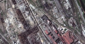
As The Russian Barrage Of The Ukraine Continues, Maxar’s Satellite Imaging Of The War Continues
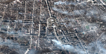
Maxar collected new high-resolution satellite imagery of Mariupol, Ukraine, on March 29th that shows extensive damage to residential apartment buildings, homes and civilian infrastructure caused by weeks of Russian artillery […]
Maxar Captures Satellite Imagery Of Damaged Russian Alligator-Class Ship In Port
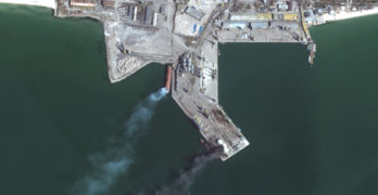
Maxar collected new satellite imagery as of March 25th of the southern Ukrainian port city of Berdyansk that reveals a Russian Alligator-class landing ship that is burned and partially submerged […]
Ukrainian Space Prospects In The Face Of War

Article by Olga Ozhogina, Freelance Space Reporter On February 28, on the fourth day of Ukraine’s fight against the Russian invader, Ukraine submitted its application for European Union (EU) membership […]
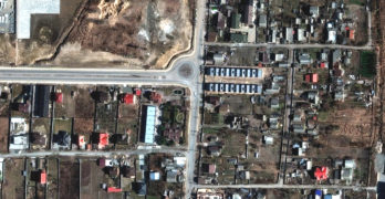
Maxar’s Satellite Imagery Captures Mariupol Area Russian Attack Damage + Flooding North Of Kyiv

As of March 22nd, Maxar has collected new high-resolution satellite images of Mariupol that vividly shows the widespread destruction caused by Russian artillery shelling and airstrikes on residential housing areas, […]
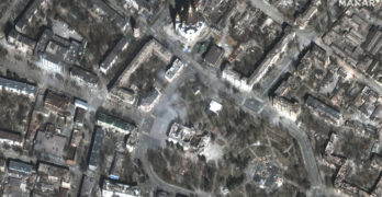
Maxar Continues To Capture Satellite Imagery Of The Russian-Ukraine Invasion
New Maxar satellite imagery collected March 18 to March 21, 2022, reveals continued Russian military activity in and around a number of key Ukrainian cities that include Mariupol, Kyiv and […]