• Skip to primary navigation
  • Skip to main content
  • Skip to primary sidebar
  • Skip to secondary sidebar
  • NEWS:
  • SatNews
  • SatMagazine
  • MilSatMagazine
  • SmallSat News
  • |     EVENTS:
  • SmallSat Symposium
  • Satellite Innovation
  • MilSat Symposium

SatNews

  • HOME
  • Magazines
  • Events
  • Perspectives
  • Industry Calendar
    • IN PERSON
    • VIRTUAL
  • Subscribe

UPDATE: Russian Assault On Ukraine Satellite Imagery Captures — Artillery + Homes / Airport Destruction / Airport Battered / Residential Damages / Chernobyl

March 12, 2022

Fuel storage tanks on fire and military equipment deployed around Antonov Airport. (Location: 50.588, 30.211)
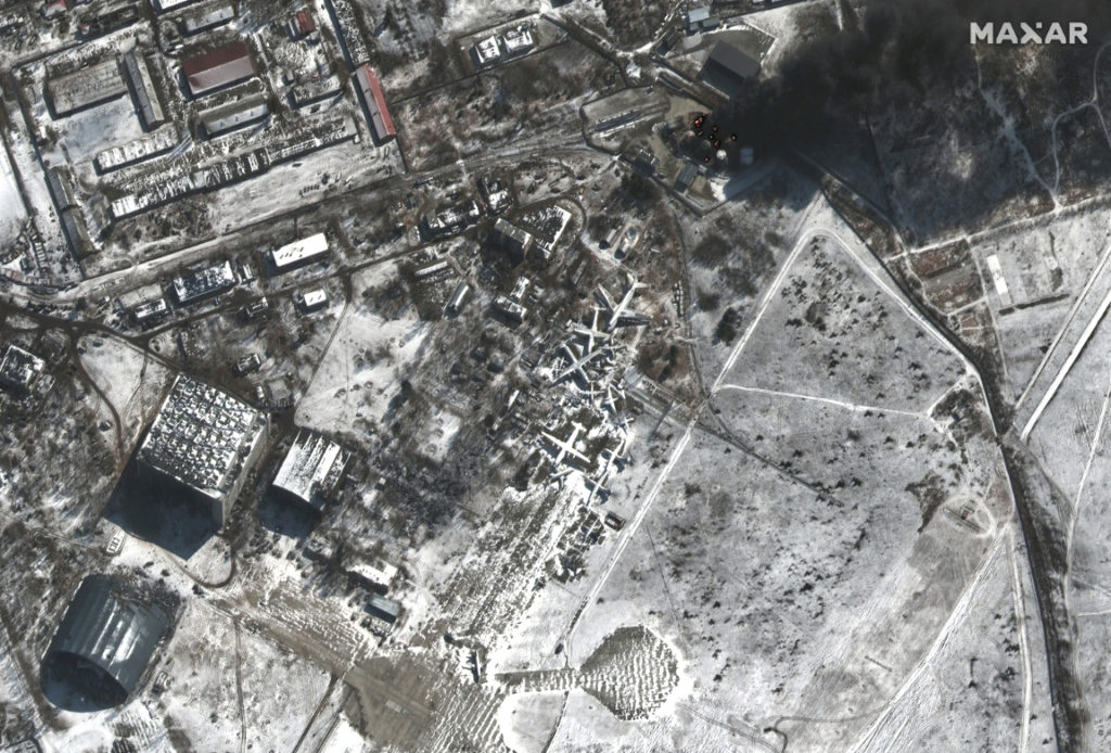
Note that image 02 was collected yesterday afternoon by Maxar’s WorldView-1 satellite (black and white imagery only) at 2:20 PM.

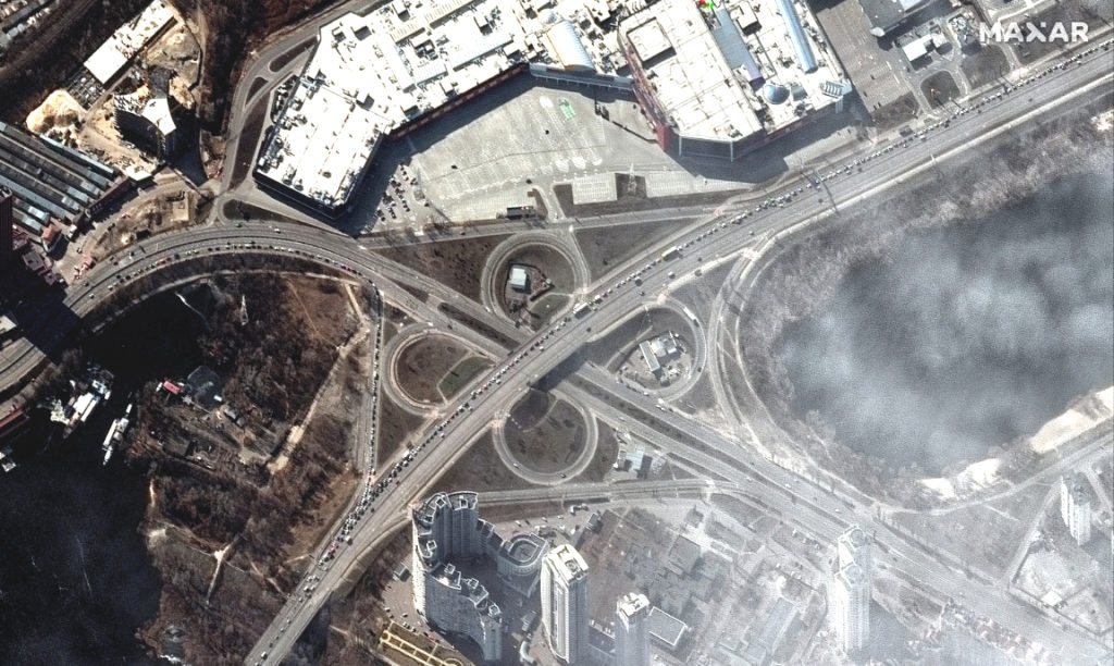
Maxar’s satellites collected an extensive amount of imagery (more than 15,000 square kilometers collected on March 11) over Kyiv, Chernihiv and Pripyat/Chernobyl that provides new visual details of the ongoing Russian military invasion in northern Ukraine.

All imagery is ©2022 Maxar Technologies.

Heavily damaged residential high-rise buildings in Borodyanka, northwest of Kyiv (Location: 50.643, 29.933)
Destroyed warehouse buildings in Stoyanka, western Kyiv region (Location: 50.444, 30.231)
Long line of cars and people leaving Irpin and damaged bridge (Location: 50.491, 30.259)

The large Russian military convoy that was last seen northwest of Kyiv near Antonov Airport has largely dispersed and redeployed.

Resupply trucks and probable multiple rocket launchers in firing position, Berestyanka (Location: 50.686, 29.994

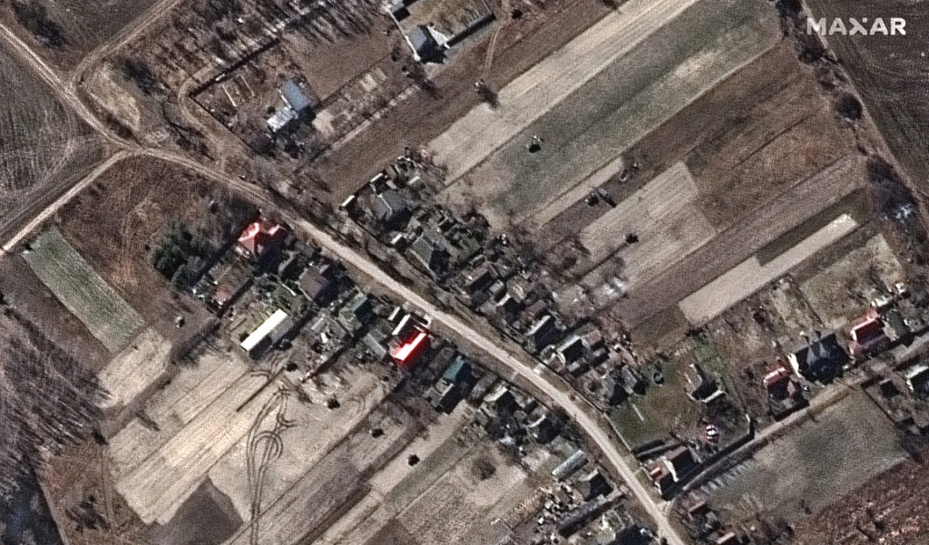
Armored units are seen maneuvering in and through the surrounding towns close to the airport, elements of the convoy further north have repositioned and are deployed in forests/along tree lines near Lubyanka with towed artillery howitzers in firing positions nearby.

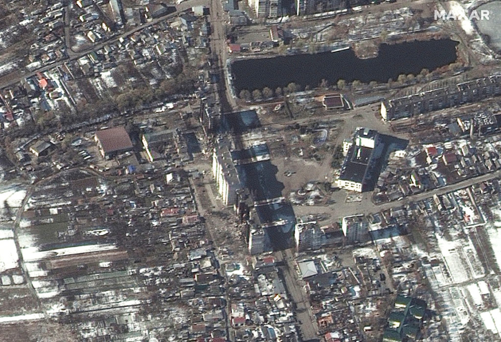
Damage to commercial and residential property is seen in and around Kyiv and also in Chernihiv, northeast of Kyiv.

Fires burning in industrial area and nearby fields, southern Chernihiv (Location: 51.463, 31.258)

New images of the Chernobyl nuclear power facility are provided.

Overview and close-up view of Chernobyl nuclear facilities (Location: 51.388, 30.099)

Maxar’s WorldView-2 satellite also collected new imagery of the Kyiv region on March 11th at 11:00 AM, local time). This imagery reveals Russian military units continuing to deploy closer to Kyiv and actively firing artillery toward residential areas.

Military deployment of armored vehicles in residential area: Ozera, Ukraine (Location: 50.615, 30.214)

Most dramatically, Maxar collected an image that shows elements of an artillery battalion actively firing in a southeasterly direction.

Multispectral satellite images of an artillery battalion actively firing in a southeasterly direction (location: 50.622m 30.199)

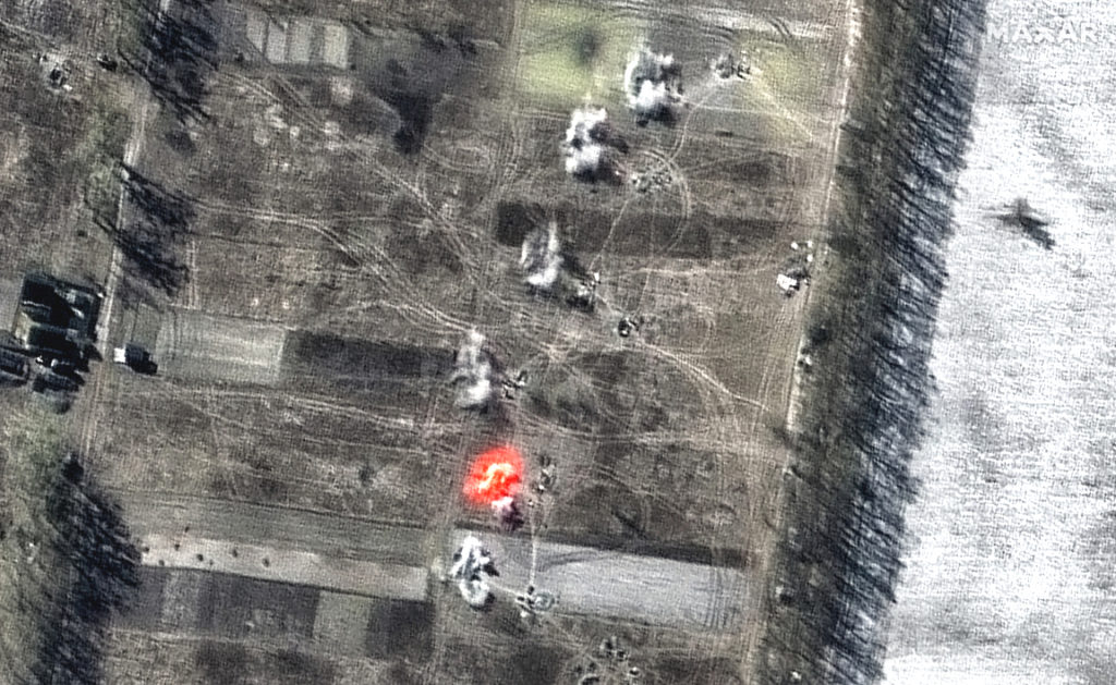
By using the multispectral imagery bands on WorldView-2, a bright muzzle flash coming from one of the artillery guns while smoke comes from five other guns can be observed, evidence that they also recently fired.

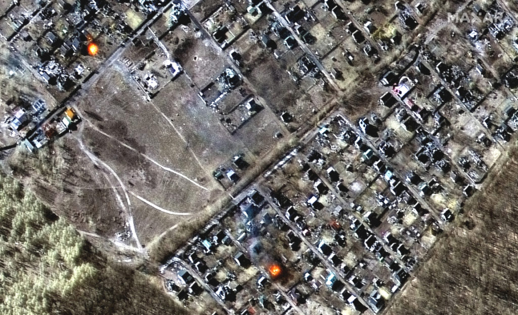
While targets of the artillery battalion cannot be confirmed, multiple homes and buildings are on fire and widespread damage and impact craters are seen throughout the town of Moschun, northwest of Kyiv and approximately seven kilometers southeast of the artillery deployment.

 Multispectral and natural color images showing destroyed homes, impact craters and fires in town of Moschun (Location: 50.613, 30.294)

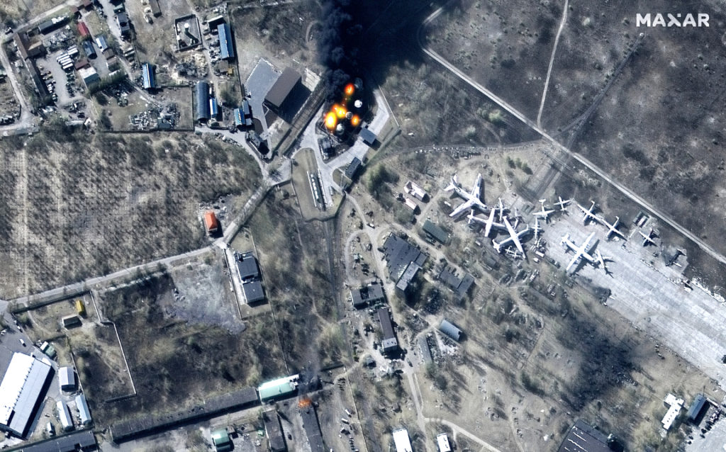
Elsewhere in the area, fires continue to burn at Antonov Airport. Maxar also used multispectral imagery on this image to show where the fires are actively burning.

Multispectral satellite image showing damage to buildings and fuel storage tanks on fire at Antonov Airport (Location: 50.585, 30.212)

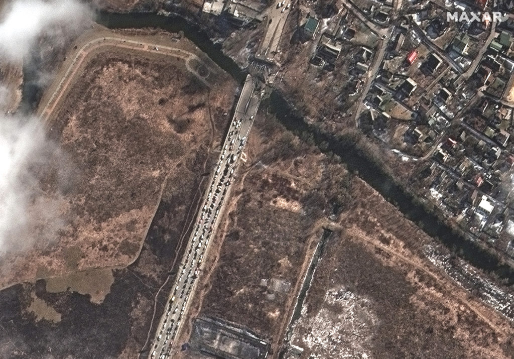
In the last image in this image collection gallery, long lines of cars are seen with people attempting to flee Kyiv.

People and long line of cars trying to leave Kyiv (location: 50.488, 30.527)

Filed Under: Earth Observation (EO), Imagery, Imaging, Multispectral, War Tagged With: Featured

Primary Sidebar

Most Read Stories

  • SpaceX Completes Two Starlink Launches In Two Days For A Total Of 106 Constellation Companions
  • Sierra Space Selects Siemens Xcelerator Software And Services For Commercial Space Venture
  • UPDATE: Blue Origin's NS-21 Mission Launch Date Is Announced
  • Continuing Their Support For USAF Geospatial Intelligence Is Raytheon Intelligence & Space
  • Maxar's Satellite Imagery Brings To Light Additional Damage To The Ukraine By Russian Attack Forces

About Satnews

  • Contacts
  • History

Archives

  • May 2022
  • April 2022
  • March 2022
  • February 2022
  • January 2022
  • December 2021
  • November 2021
  • October 2021
  • September 2021
  • August 2021
  • July 2021
  • June 2021
  • May 2021
  • April 2021
  • March 2021
  • February 2021
  • January 2021
  • December 2020
  • November 2020
  • October 2020
  • September 2020
  • August 2020
  • July 2020
  • June 2020
  • May 2020
  • April 2020

Secondary Sidebar

x
Sign up Now (For Free)
Access daily or weekly satellite news updates covering all aspects of the commercial and military satellite industry.
Invalid email address
Notify Me Regarding ( At least one ):
We value your privacy and will not sell or share your email or other information with any other company. You may also unsubscribe at anytime.

Click Here to see our full privacy policy.
Thanks for subscribing!